Regulation 18 draft Local Plan
(11) Chapter 5 – Spatial Strategy
The Spatial Strategy provides the overall framework for the quantity of development that should be planned for, and where this development is to be directed, linked to the roles of the towns and villages in Rutland. It identifies settlements that are suitable locations for sustainable development and is a key factor underpinning the distribution of development.
The Spatial Strategy seeks to reflect the long-term Future Rutland Vision which states that:
Rutland's market towns of Oakham and Uppingham will thrive as vibrant destinations to shop, socialise and enjoy life – both for those who live locally and the many thousands of people who come to the County every year.
Towns and villages will promote inclusion, retain their sense of identity, and encourage even greater community spirit – all things that help to give Rutland its distinctive feeling of closeness, familiarity, and security.
Wherever new homes are needed, they will be built in a way that protects and enhances the things that matter most to everyone – Rutland's sense of community and its unique rural identity.
What will this policy do?
A number of factors contribute to quality of life and help make Rutland a good place to live, work and study. For the success of the County to continue, it is important to make sure the Local Plan provides for the appropriate levels of growth in a way that will deliver sustainable development.
Policy SS1 establishes the levels of employment and housing needed for the plan period and sets out where this development should be located to support the local economy and provide for housing needs. It must do this whilst maintaining the quality of life for residents as well as the quality of the natural and built environment.
Policy SS2 establishes the information and evidence which will be required to support planning applications submitted in Rutland over the plan period.
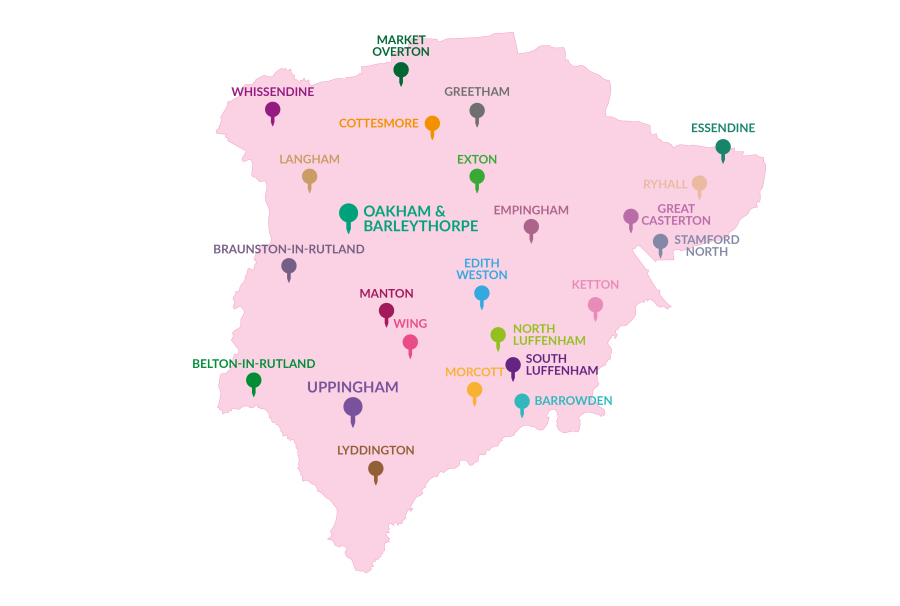
(75) Policy SS1 - Spatial strategy for new development
Sufficient land will be allocated in the Local Plan, which, together with existing commitments and development built since 2021, will deliver:
- at least 123 dwellings per annum (2460 over the 20-year period 2021-2041) and
- about 27 ha for new employment generating uses, (with the aim of generating additional jobs) over the Plan period 2021-2041 to address the objectives of the Economic Strategy.
- The majority of new development will be focussed within the Planned Limits of Development (PLDs) of Oakham (and Barleythorpe) and Uppingham, and on land adjacent to Stamford (which lies within South Kesteven District adjoining the County boundary). This will be met by allocated sites and through windfall sites within the planned limits of Development.
- In the defined Larger Villages listed below, development of allocated sites and windfall sites within the Planned Limits of Development will be permitted:
- Barrowden
- (24) Belton
- (4) Braunston in Rutland
- (5) Cottesmore
- (13) Edith Weston
- (3) Empingham
- (1) Essendine
- (1) Exton
- (6) Great Casterton
- (1) Greetham
- (4) Ketton
- (1) Langham
- (3) Lyddington
- (13) Manton
- (2) Market Overton
- (4) Morcott
- (2) North Luffenham
- (2) Ryhall
- (1) South Luffenham
- (7) Whissendine
- (1) Wing
Proposals for housing development on greenfield sites adjoining the Planned Limits of Development of Oakham and Barleythorpe, Uppingham and the Larger Villages will only be released in exceptional circumstances where it is demonstrated that they are needed to maintain a sufficient supply of deliverable and developable land. This will normally be undertaken through a review of the Local Plan.
- Development will be limited to small scale redevelopment and infill opportunities only, in the following smaller villages and hamlets listed below:
- (2) Ashwell
- Ayston
- Barrow
- Belmesthorpe
- Bisbrooke
- Brooke
- Burley
- Caldecott
- (2) Clipsham
- Egleton
- (1) Glaston
- Gunthorpe
- Hambleton
- Little Casterton
- Lyndon
- Pickworth
- (1) Pilton
- Preston
- (1) Ridlington
- Seaton
- Stoke Dry
- Stretton
- Teigh
- Thistleton
- Thorpe by Water
- Tickencote
- (1) Tinwell
- Tixover
- Wardley
- Whitwell
Places not identified above are considered to be part of the wider countryside where development will only be appropriate if permitted by other policies of this plan, a neighbourhood plan or national policy.
(15) Policy SS2 - Requirements for planning applications
Planning applications must be supported by sufficient information and evidence to demonstrate compliance with all relevant policies included in this plan. The level of detail provided should be proportionate to the nature of the development proposed, its scale, the sustainability of the settlement, and the sensitivity and constraints of the site and its setting.
Planning applications for new development should be accompanied by a Design and Access Statement setting out how the proposal has been developed to respond to local policy and guidance including adopted SPD, Neighbourhood Plans, Design Guides, Design Briefs, and Design Codes.
Why is this policy needed?
The NPPF requires the Local Plan to provide a spatial framework for addressing housing needs and other economic, social, and environmental priorities. It states that strategic policies should set out an overall strategy for the pattern, scale, and design quality of places, and make sufficient provision housing, employment, retail and leisure and other commercial development. Establishing a clear spatial strategy directs development to those locations which are suitable for sustainable development and economic growth. Defining the spatial strategy underpins the scale and distribution of development which will meet the identified needs for the County for the plan period.
The above approach is intended to meet the minimum housing requirement set out in the Government's calculation of Rutland's Local Housing Need (LHN). However, it is recognised that there are limits to the continued development being added on to the edges of existing settlements. Equally, the Future Rutland Vision looks to a longer time period than the proposed plan period for the Local Plan.
The spatial strategy included in the adopted Core Strategy 2011 has been reviewed to assess whether it remains appropriate. The new spatial strategy recognises the following key roles and relationships of the County's towns and villages:
Oakham is the main town of the County, with range of job opportunities, higher order services including retail, leisure and health facilities for the surrounding rural area and has good public transport links. Existing commitments and new allocations for housing and employment development will seek to sustain its prominence as the main service centre serving the villages in Rutland for shopping, employment, and local services.
Uppingham is the second largest settlement in the County and also serves a rural hinterland through the provision of a wide range of services and facilities within the town. Despite a positive approach to allocating land for housing and employment development in the made Uppingham Neighbourhood Plan, past rates of development in Uppingham have been lower than envisaged through the Core Strategy DPD plan period to date.
Uppingham Town Council are reviewing this made Neighbourhood Plan and propose additional housing and employment land to be allocated to meet the needs of the town for the new Local Plan period. The Local Plan seeks to provide the strategic context to enable locally determined, appropriate additional allocations to be made through the Uppingham Neighbourhood Plan.
Oakham and Uppingham are the most sustainable locations for new development and therefore allocations for the majority of new houses and job opportunities will be located in the towns.
The Rutland County boundary with Lincolnshire is close to the town of Stamford in South Kesteven. Evidence has shown that the most appropriate location for the future growth of the town of Stamford is to the north of the town. This development needs some land located in Rutland in order to achieve a comprehensive and sustainable development. This plan therefore includes a proposal for land to form the western end of a larger urban extension to the north of Stamford.
The County's larger villages are defined as those which may have a number of key local services such as a shop, public house, community centre, school and/or recreation and leisure spaces. However, some of these facilities are commercial operations and may close (or open) during the plan period without the need for planning permission. The background paper identifies that villages with more than 150 homes and a population of more than 300 people can sustain a local shop or public house and a community centre and recreation spaces. Therefore, these villages are identified as the Larger Villages where a limited amount of development may help to maintain or enhance their vitality, support existing community facilities, and meet local needs. The spatial strategy lists the larger villages and allocations for small and medium scale housing development are made in some of these villages. (see Chapter 6 Housing).
There are also a large number of smaller villages and hamlets spread across the County. The small villages and hamlets are defined as those with less than 150 houses and a population of less than 300[1] people. These villages have few or no local facilities and the scale of development required to bring such facilities to the village is likely to be much larger than the existing settlement pattern would accommodate. Promoting development in these villages would not encourage sustainable patterns of growth. In these locations development will, therefore, be limited to small scale infill and redevelopment opportunities.
What you told us about this topic
The Issues and Options consultation asked about the spatial strategy for housing growth under Issue 2. Most of those responding to the Issues and Options consultation responded to this question with the majority of respondents (41%) opting for the option to continue with the Core Strategy apportionment of growth between the towns and the villages.
As a result of the consultation responses the Council committed to reviewing and updating the settlement hierarchy which underpins the spatial strategy.
What alternatives have we considered?
The background paper considers the merits of retaining the existing settlement hierarchy of towns, Local Service Centres, Small Service Centres and Restraint Villages
Which existing policies will be replaced by this policy?
CS2 - The spatial strategy
CS3 - The settlement hierarchy
CS4 - The location of development
Location of Development
What will these policies do?
Planned Limits of Development (PLDs) have been drawn around the two towns and the 21 Larger Villages identified in the development strategy at SS1. The PLDs define the area within which development will generally be considered acceptable in principle and policy SS3 establishes that development proposals within the PLD will be supported in principle.
PLDs have not been defined for the small villages and hamlets. Instead, Policy SS4 allows for some very limited development in and around these settlements as infill, rounding off and appropriate redevelopment of previously development land. This approach will help to protect small settlements and the open countryside from inappropriate development in terms of sustainable development and landscape and townscape character, whilst also allowing some flexibility to allow for limited growth through the application of policy criteria.
(39) Policy SS3 – Development within Planned Limits of Development
Within the Planned Limits of Development (PLDs) indicated on the Policies Maps, planning applications for development will be supported in principle, in accordance with the presumption in favour of sustainable development, where impacts on settlement form, built heritage, character and important open space are considered acceptable.
It should be noted that not all development will be acceptable within the PLDs as proposals will be considered on their own merits with regard to the policies of this plan and any made Neighbourhood plan.
This is a strategic policy and significant changes to PLDs defined through the neighbourhood planning process will be incompatible with it. This does not however prevent Neighbourhood Plans from proposing small scale adjustments to PLDs to allow for additional development which meets their community's needs. Where such allocations are made in a neighbourhood plan the PLD will be reviewed and amended by the subsequent Local Plan review.
(31) Policy SS4 – Infill and rounding off development in smaller villages and hamlets
In the small settlements (listed in Policy SS1c)) which do not have a Planned Limit of Development, small-scale infill, redevelopment and rounding off development (defined as 5 or less dwellings) may be permitted, provided that it is demonstrated that the proposal:
- Is for the redevelopment of a previously developed site; an infill plot within a substantially built-up frontage; or a site where development will complement or enhance the existing settlement edge;
- Is of a proportionate scale and density and reflects the existing pattern of development;
- Does not harm erode or harm the public amenity of open spaces or gaps that contribute to the character of the village, including sites identified in the Important Open Spaces and Frontages;
- Supports or enhances the vitality of the local community;
- Maintains and/or complements the form and character of the settlement;
- Does not have an adverse cumulative impact on the settlement with regard to other developments permitted during the plan period; and
- Is designed to be sensitive to its landscape character and setting with specific reference to the Rutland Landscape Character Assessment 2022.
Why is this policy needed?
To promote sustainable development in the countryside, the NPPF expects housing to be located where it will enhance or maintain the vitality of rural communities. The NPPF also says that planning policies should be responsive to local circumstances and support housing developments that reflect local needs and policies should identify opportunities for villages to grow and thrive, especially where this will support local services.
Development within Planned Limits of Development
Planned Limits of Developments (PLDs) define the extent of existing built-up areas of the main towns and larger villages in the County. Development within PLDs is considered to be acceptable in principle, subject to compliance with detailed polices in this plan. It should not, however, be assumed that all land within the PLDs has potential for future development. PLDs have the following functions:
- define where development will be acceptable in principle because it meets the objectives of delivering sustainable development;
- prevent inappropriate development (or encroachment) across into the countryside and open areas;
- control the scale and location of development by establishing the limit for the outward expansion of settlements;
- encourages sustainable redevelopment within settlements
The PLDs defined in the Local Plan have been reviewed and updated in accordance with new criteria set out in the Rutland Planned Limits of Development Review report 2023. In addition to the criteria and methodology set out in the review the PLDs have also been amended to include within the boundaries:
- site which are under construction or where planning permission has been granted.
- sites which are allocated for development in this Local Plan or made Neighbourhood Plans to 31.03.23
Defining PLDs help to maintain a sustainable development strategy by focusing the majority of new development in the County's most sustainable settlements, where there is better access to services facilities and job opportunities and better transport links.
Development in small villages and hamlets without a Planned Limit of Development
Rutland has a large number of very small villages and hamlets which have few or no services, facilities, or job opportunities. Many of these settlements have a rural character that often merges into the surrounding countryside. These settlements are not sustainable locations for housing growth. Therefore, Planned Limits of Development have not been defined around them and no land has been allocated for development.
Despite this, there may be opportunities for local, very small-scale development to take place to support the viability and vitality of the village in accordance with the NPPF. Such development will be limited to infill sites, rounding off and through re-use and redevelopment. Any housing development that is permitted in these locations will be 'windfalls' to the housing land supply.
Very small-scale development means that which is proportionate in scale and density, and complementary with, the size and character of the settlement and its surroundings. It is expected that housing development on such sites will usually be 1-2 new dwellings, although exceptionally there may be sites which yield up to a maximum of 5 dwellings.
Any development provided through this policy also needs to be in keeping with the rural character of the locality. Care should be taken that such development, does not harm open spaces or gaps that make a positive contribution to the character of the village, including views and vistas, particularly sites identified as Important Open Spaces. Careful consideration also needs to be given to the cumulative impact of new development which can, over time, erode the character of rural settlements and/ or lead to the coalescence of groups of buildings to produce a more 'urban' form.
Development of isolated sites outside the existing pattern and form of a settlements will not be considered acceptable.
Definitions
Previously developed land is defined in the National Planning Framework.
Infill development is defined as a small gap within a continuously built-up frontage.
small scale (for the purpose of this policy) means development of 5 dwellings or fewer)
What you told us about this topic
In Issue 6 of the Issues and Options consultation we asked whether the PLDs should be reviewed. 65% of those responding to this question agreed that they should be reviewed. You also told us that reviewing the PLDs should provide some flexibility to allow for some organic growth and to include new allocations.
We have commissioned a review of the methodology and criteria for establishing and reviewing PLDs and a full review of PLDs for the two towns and the 21 Larger Villages. This is reported in a format which allows comments to be made on each proposed boundary change.
What alternatives have we considered?
To remove all PLDs and rely on criteria-based policies; to review all PLDs including those for the small villages and hamlets.
The preferred approach which has resulted in policies which provide a combination of PLDs for the towns and larger villages and criteria-based policy to help determine applications for small infill, windfall, and redevelopment proposals on a site-by-site basis in the smaller villages without a PLD. This approach allows for some flexibility to allow for very small-scale growth in appropriate locations.
Which existing policies will be replaced by this policy?
CS3 - The settlement hierarchy
CS4 - The Location of Development
SP5 - Built development in towns and villages
Large scale development and new settlements
What will this policy do?
This policy establishes the parameters for developing a separate Development Plan Document to consider the reuse or redevelopment of the St George's Barracks site once it is vacated by the Ministry of Defence. with no allocation being made in this Local Plan. Instead, the site is identified as a Future Opportunity Area and the policy below provides a framework to help ensure any redevelopment is sustainable and holistically planned.
It is expected that the site will be vacated by 2026; at that time, it would constitute "previously developed land" (a brownfield site).
It is likely that the site may be appropriate for meeting some future development needs either for this plan period and/or beyond, and in so doing could ease the pressure for future development on greenfield land. However, there are considerable complexities in considering the future use of this site, and it is proposed to explore these matters through a separate Development Plan Document (DPD),
(138) Policy SS5 – St. George's Barracks Opportunity Area
St. George's Barracks is identified as an opportunity area and is defined on the Policies Map as SS5.
This policy provides a framework to help ensure any redevelopment is sustainable and holistically planned and is aligned to the spatial strategy set out in this plan.
The preparation of a masterplan with the status of a Development Plan Document, will be required prior to a planning application being submitted. Major development proposals on the site not detailed in a masterplan, or any proposals that will result in a conflict between uses will not be supported.
Redevelopment proposals are not expected to deliver more than between 350 and 500 dwellings as part of a mixed-use development.
The site masterplan will be expected to:
- set out the layout, mix and scale of uses, including the relationship with existing uses
- a balanced and inclusive community, providing a mix of the type and tenure of uses. Where this includes housing, it will be expected to meet the needs of all sections of the community (including provision for gypsy and traveller accommodation) alongside the provision and promotion of opportunities for employment;
- establish design parameters covering building heights, materials, landscaping, circulation, key features, and views, creating a distinctive environment respecting the site's designated and non-designated heritage assets;
- be accompanied and influenced by a Heritage Impact Assessment identifying the potential impact of development on heritage assets and an evaluation of the known and potential archaeological significance of the area. In particular, the masterplan should demonstrate that the Thor Missile site (a grade II* listed building) and the setting provided by the former airfield runways are satisfactorily protected;
- assess impacts on the landscape, views into and out of the site and proposed mitigation to make any impacts acceptable;
- demonstrate how the scheme will protect and enhance the natural environment and ecological networks, including the presence of any significant or protected habitat and or species, ensuring a minimum 10% biodiversity net gain and an assessment of likely impacts on ecology generally and on Rutland Water with proposed mitigation measures;
- detail the delivery of an adequate amount and range of infrastructure to support the uses and community on the site which must be delivered in tandem with or ahead of development;
- provide a detailed transport assessment including proposals for the delivery of sustainable transport and active travel linking the development with other key settlements in Rutland to ensure that reliance on the private car is minimised on the site;
- be supported by a site-specific energy and embodied carbon strategy for the site which investigates the opportunities on the site to deliver net zero carbon development including the potential to offset the energy use of existing homes on the site;
- detail the engagement that has taken place with the community and necessary infrastructure providers and how any necessary mitigation identified has been incorporated in the masterplan;
- demonstrate that adequate utilities provision can be achieved to support the scale of development proposed;
- identify how the scheme will integrate with the existing community;
- set out details of phasing of development and infrastructure and construction management plans including assessment of the impact on the community;
- address issues related to impact on safeguarded mineral reserves;
- provide a clear demonstration that the proposed scheme will be deliverable and viable; and
- detail how the scheme will satisfy the policies of the Local Plan and relevant Neighbourhood Plans.
- development proposals on the site that are consistent with the approved masterplan will be supported.
Why is this policy needed?
The NPPF advises plan makers that the supply of a large number of new homes can often be best achieved through planning for larger scale development, such as new settlements or significant extensions to existing villages and towns, provided that they are well located and designed, and supported by the necessary infrastructure and facilities.
In November 2016, the Ministry of Defence announced that the St George's Barracks site located between the villages of Edith Weston and North Luffenham would close. The timetable for the site to close has been extended and it is now expected that it will be vacated in 2026.
The site is significant in size, extending to about 265 hectares. About a third of the site in the northwestern corner comprises military housing, a community shop, workshops, aircraft hangers, open space and sports and recreational facilities and infrastructure associated with its current and former military uses. This area of the site would be suitable for re-use and or redevelopment once the site is vacated. The remaining site is subject to ecological, geological and heritage constraints which would significantly restrict opportunities for re-use or redevelopment.
This site includes extensive areas of airfield land, technical buildings, and housing and community and leisure facilities for use by service personnel. With the expected closure of the barracks, there is an imperative to plan for the future use and development of the site which also accommodates a Grade 2* listed structure (Thor Missile site) and a significant area identified as a mineral safeguarded area.
Development proposals for the re-development of the sites remain uncertain at the point of preparing the Local Plan, therefore no specific proposal is included for the site. However, the plan needs to ensure that a policy framework is in place to guide the development of proposals and to help ensure any redevelopment is sustainable and holistically planned and aligned to the spatial strategy set out in this plan. The site is therefore identified as a future opportunity area which would be the subject of a separate development plan (DPD).
Once vacated the site will become a major brownfield site. National planning policy requires councils to make the most effective and efficient use of brownfield land and it is expected that the Ministry of Defence will want to explore all opportunities for the re-use and reclamation of the site.
The barracks were established on the site of the former RAF North Luffenham airfield in 1998. They became the home of the Royal Regiment of Fusiliers in 1999, of the King's Own Royal Border Regiment in 2003 and of the 16th Regiment Royal Artillery in 2007. In April 2013 16th Regiment Royal Artillery received the Freedom of Oakham on behalf of the barracks. In July 2014 16th Regiment Royal Artillery moved to Baker Barracks, Thorney Island. 2 Medical Regiment, Royal Army Medical Corps and 1 Military Working Dogs Regiment, Royal Army Veterinary Corps moved into St George's Barracks later that year.
Prior to the Army taking over the site in 1998, it was used by the RAF. The station was built as a training airfield, opening in 1940. It was later taken over by 5 Group of RAF Bomber Command as a heavy bomber base and was expanded by the building of concrete runways later in the war.
From 1959 to 1963, North Luffenham was the base for PGM-17 Thor intermediate range ballistic missiles, operated by No. 144 Squadron RAF. The Thor missile site was listed as a Grade II* building in 2011.
When the RAF vacated the base, the gates from the main entrance were donated to the village of North Luffenham. The gates which bear the station badge were later erected at the entrance to the village's recreation ground.
The site includes a number of military buildings on the edge of Edith Weston and is also close to North Luffenham. The military heritage is deeply ingrained in the site including listed buildings related to the Thor missile site, current operational buildings, streets, spaces, trees, and landscaping and therefore what remains when the operational use of the site ceases will continue to be influenced by its military past.
There is already a community at St. George's and this will continue to be the case once operational use ceases. It is vital that the future of the community is well managed to ensure a sustainable future for current and future residents. Therefore, this Local Plan will look to ensure that the impacts of this change are well managed to deliver the best possible outcomes for the community through future joint working between the County Council, Ministry of Defence, and other involved partners in terms of planning for its future sustainable development in line with the spatial strategy set out in this plan.
Key issues include:
- the unique and important site is of national significance in its heritage.
- the specific nature of the site and challenges in relation to integration and improved access both across the site itself and to other settlements, supporting connectivity and future sustainability.
- the risk of fragmented nature of current infrastructure across the site and challenges around infrastructure specification and standard affecting opportunities for future public authority adoption.
- the relationship of new development to neighbouring communities.
- the scope for the retention and development of existing employment opportunities.
The St. George's site offers the opportunity to provide for appropriate employment as part of a comprehensive development proposal.
What you told us about this topic
Q13 Option E of the Issues and Options consultation asked about meeting growth through a new settlement, although St George's was not specifically referenced. 18% of those responding supported this option.
What alternatives have we considered?
Alternative options are to not consider St George's specifically but to rely on policy SS7. However, this approach does not enable the council to be proactive in the development of a positive planning approach for the site which engages the local communities and other stakeholders.
The Council has also received proposals for the development of a new community at Woolfox, adjacent to the A1 near Stretton. The proposal submitted through the Call for Sites has an expected capacity of at least 4,000 houses together with over 100 hectares of employment land. The scale and nature of the proposal is not considered to be deliverable within the context of the assessed employment and housing needs for Rutland for this plan period. Allocating a development of the scale and nature proposed for Woolfox would compromise the delivery of the proposed spatial strategy set out in this plan and potentially the plans of neighbouring areas.
A proposal of the scale and nature envisaged by the Woolfox proposal could only be considered on a sub-regional basis and justified as contributing to the needs of neighbouring authorities. At present, there is no opportunity to take such a proposal forward.
Like St George's the Woolfox site is also subject to environmental and geological constraints and similarly there are uncertainties and complexities to a development in this location. Unlike St George's, the Woolfox site is not considered to meet the definition of previously developed land.
This Local Plan does not, therefore, allocate the Woolfox site. It is recognised, however, that the site may contribute to meeting future development needs of Rutland, particularly if it is possible to develop a sub-regional basis for its consideration. Future proposals for this site would need to be assessed and considered either through the review of this plan or potentially beyond the current plan period.
Supporting Evidence
Whilst large amount of evidence was prepared to support the previous proposal for the site it is expected that a new evidence base will be required as part of the preparation of the separate plan for St Georges
Which existing policies will be replaced by this policy?
CS6 – Reuse of redundant military bases and prisons
Military Sites and Prisons
What will these policies do?
Operational facilities in Rutland currently include Kendrew Barracks at Cottesmore (formerly RAF Cottesmore), St George's Barracks at North Luffenham and HMP Stocken. It is expected that the use of these facilities will change and may need to expand during the plan period. A separate policy (SS5) is included for St George's Barracks which is expected to close in 2026. Policies SS6 and SS7 will not apply to the redevelopment of St Georges Barracks.
The following two policies will enable the Council to plan positively for the continuing operational use and potential change of use which may arise from these sites during the plan period.
(11) Policy SS6 – Use of military bases and prisons for operational or other purposes
Development required for the continued operation of military bases or prisons will be acceptable within the areas shown on the policies map, provided that, wherever possible, it would:
- re-use previously developed land and buildings;
- keep the use of undeveloped land to a minimum and is justified on the basis of national prison or defence requirements;
- not lead to undue disturbance to nearby local communities through traffic, noise, military, or prison activity;
- protect and enhance the countryside and character of the landscape, natural and cultural heritage;
- provide satisfactory access arrangements and not generate unacceptable levels of traffic on the surrounding highway network;
- incorporate high quality design which makes provision for energy efficiency, renewable energy, and waste management;
- incorporate satisfactory water and wastewater arrangements ensuring there is no increased risk of flooding and pollution;
- ensure that potential risks from former uses of the sites are assessed and that soil and groundwater are cleaned up where necessary.
The small-scale development of an individual building, or part of a military base or prison for alternative uses which are not required for the operation of the establishment, will be given favourable consideration provided that it complies with the key requirements set out in Policy SD6 (Re-use of redundant military bases and prisons) and that it would not adversely affect the operational use of the establishment.
(17) Policy SS7 – Re-use of redundant military bases and prisons
Any proposal for the re-use or redevelopment of redundant military bases and prisons should be planned and developed in a comprehensive and co-ordinated manner.
Proposals must be in accordance with an agreed development brief or masterplan setting out the main requirements of the scheme. This could form part of a supplementary planning document or a development plan document to be prepared in consultation with the landowner, prospective developers, the Council and local communities.
The key requirements for any proposals are that they should:
- re-use existing land and suitable buildings and where appropriate minimise any built development on undeveloped land within the curtilage; and
- minimise disturbance to nearby local communities through traffic, noise, other activities or uses;
- protect and where possible, enhance the countryside and character of the landscape, natural and cultural heritage;
- be subject to a transport assessment demonstrating that the proposal can be accessed satisfactorily, or mitigate unacceptable traffic impact on the surrounding road network and will be accessible or could improve access by public transport and include measures to encourage walking and cycling;
- incorporate high quality design and construction including the need for energy efficiency, renewable energy, and waste management;
- Ensure appropriate new and/or improved physical, social and community infrastructure is provided to serve the needs arising from the proposed development and during construction;
- Be subject to a contamination and site condition survey
Why are these policies needed?
Operational facilities in Rutland form an important part of the local economy and community. Sites generally include extensive areas of land and buildings including ex-airfields, technical buildings, community, and leisure facilities for use by service personnel, as well as military housing.
Development in connection with the use of military bases and prisons will normally need planning permission with the exception of some special arrangements concerned with national security and defence urgency and enforcement.
Sites are often located in remote countryside locations where new development would normally be restricted; it is recognised however that some flexibility may be needed where development is needed for operational purposes. Policy SS6 for operational uses of military and prison sites recognises the need to be flexible in considering proposals which are necessary for the continuing operation of such sites. Site boundaries within which the policy applies are shown on the Policies Map. Operation uses will not be expected to extend beyond these boundaries. The policy also allows for the alternative use of an individual building or part of a military base or prison where it is small in scale and would not adversely affect the use of the area for operational purposes.
Proposals for the re-use of a redundant military base or prison other than St George's (which is covered by a separate policy) are likely to be significant and may need to be considered via a review of the local plan or through the development of a separate Development Plan Document. Policy SS7 sets out the key requirements that need to be considered for any alternative uses of the remaining military base or prison setting out criteria relating to the re-use of existing land and buildings, disturbance to local communities, protecting the countryside, landscape and ecology, accessibility, design and construction, renewable energy, and energy efficiency. The detailed requirements of any alternative uses would need to be the subject of a master plan or development brief or through a development plan document and must be based on robust evidence. Proposal will be subject to publicity and consultation. Major proposals, beyond those proposed within this plan, would need to be considered in the context of the spatial strategy and are likely to trigger the review of this local plan.
What you told us about this topic
No questions were included on this topic in the Issues and Options consultation.
Which existing policies will be replaced by this policy?
CS6 - Reuse of redundant military bases and prisons
SP11 - Use of Military Bases and prisons for operational and other purposes
Development in the open Countryside
What will these policies do?
Rutland is a largely rural county. This rurality together with the attractive open landscapes, mean that non-essential development in the rural countryside of the County is inappropriate and will be restricted. However, there are certain types of development which are considered essential to maintain a thriving and active rural community and economy. Policies SS8 and SS9 set out the types of development which are considered acceptable subject to the specific criteria included within policies and policy SS10 provides criteria against which proposals for the conversion of existing buildings in the countryside will be considered.
(19) Policy SS8 - Residential development in the open countryside
New-build open market housing will only be permitted in the open countryside where the proposal is for the following uses and which specifically meet the requirements of NPPF and subject to the relevant policies of this plan:
- Affordable housing on rural exceptions sites (Policy H8)
- Housing to meet a proven essential need for rural workers
- Re-use, adaptation, and conversion of rural buildings (Policy SS10)
- Gypsy, Traveller and Travelling Show People sites (Policy H10) to help meet identified accommodation needs
(13) Policy SS9 – Non-residential development in the countryside
Non-residential development in the countryside will only be supported where it is for one of the following purposes:
- essential for the efficient operation of a rural use (such as agriculture, horticulture, equestrian or forestry uses); or
- essential for the provision of sport, recreation, and visitor facilities where the countryside is the only appropriate location;
- essential investment in infrastructure including utilities, renewable energy and roadside services required for public safety purposes;
- a rural enterprise comprising small scale alterations, extensions, or other development ancillary to an existing established use which is appropriate in the countryside;
- new employment growth comprising sustainable rural tourism, leisure, or rural enterprise that creates local employment opportunities and supports the local economy and communities and where no acceptable alternative can be identified within existing permitted or allocated sites, or within or through redevelopment of existing commercial premises;
- an appropriately sized extension of an existing employment site, which will not intensify uses at the site to the detriment of existing public access routes and highways;
- Economic projects which have a functional need to be located in the countryside and where the economic benefit to the County demonstrably and significantly outweighs any harm and there are no unacceptable adverse environmental impacts
- farm diversification that supports waste management development; or
- mineral development that supports the provision of minerals for aggregate purpose, cement production, locally sourced building materials or processing of recycled aggregate; or
- involves the conversion of existing rural buildings for business and employment generating uses in accordance with policy SS10.
All proposal will be expected to demonstrate that:
- the development cannot reasonably be accommodated within or adjoining the Planned Limits of Development of towns and villages;
- the amount of new build or alteration is kept to a minimum and the local planning authority is satisfied that existing buildings available elsewhere in the County are not suitable for the purpose;
- the development itself, or cumulatively with other development, would not be detrimental to the character and appearance of the landscape, visual amenity, and the setting of towns and villages and is of a scale, design, and layout appropriate to the context;
- d) the development would not generate an unacceptable increase in the amount of traffic movements, and it is capable of being served by public transport or otherwise is readily accessible by means other than by private car to a significant residential workforce if employment intensive uses are proposed;
- Access arrangements and parking facilities will be provided in accordance with the Council's adopted standards;
- A sympathetic relationship and scale to the surrounding areas that shows consideration of the landscape, habitat, built and historic environment contexts, the opportunities to deliver on-site habitats and protect key species.
- A satisfactory relationship with neighbouring uses in order that the amenities of nearby residents, in particular, are protected; and
- Where appropriate, crime prevention measures are incorporated.
(6) Policy SS10 - Conversion of buildings outside PLDs
Proposals for the conversion of existing buildings in the countryside outside the Planned Limits of Development will only be permitted provided that:
- The building is structurally sound, of permanent construction, and capable of conversion without rebuilding or significant alteration or extension;
- The resultant building use will not have an adverse effect on the rural character of the area in respect of the nature and level of activity likely to be generated, including the resultant traffic level;
- The resultant building and ancillary areas are sympathetic to its setting in terms of form, bulk and visual design;
- Where the building is of historic or architectural importance, there is no adverse effect on the character and appearance or features of architectural or historic interest, internally and externally, which the building possesses, or its setting; and
- The traffic to be generated by the new use can be safely accommodated by the site access and the local road system.
A structural survey may be required to demonstrate that the building is capable of conversion. Provision for accommodating protected species identified by survey will be incorporated into the scheme. Where necessary, planning conditions will be imposed removing relevant Permitted Development Rights under the General Permitted Development Order.
(7) Policy SS11 - New agricultural buildings
Agricultural buildings will be permitted in the countryside provided that:
- Their scale, siting, design, materials and use of landscaping minimise the visual impact on the landscape and ensure they are not prominent on the skyline; and
- New buildings are grouped with any existing buildings. Isolated buildings will only be permitted where their location is essential to the agricultural activity being undertaken and where they are not situated in a prominent location; and
- They will not have an adverse effect on residential amenity in terms of noise, dust, smell or disturbance from vehicular movements
- If housing livestock, they are not within 75 metres of a watercourse unless the Council is satisfied that all biological run offs of waste can be contained.
Why are these policies needed?
Housing
To promote sustainable development in the countryside, the NPPF expects housing to be located where it will enhance or maintain the vitality of rural communities. In the absence of special circumstances, local planning authorities should avoid permitting new isolated homes in the countryside. Exemptions to this are made within NPPF for specific types of housing.
Policy SS8 above is intended to preclude the development of new-build open market housing which, for strategic reasons, is not needed in the countryside. The policy does not, however, preclude the development of specific types of open market housing in rural locations; for example, dwellings resulting from the conversion of rural buildings. It would also not prevent alterations to, or extensions of, existing buildings. There is a significant lack of Gypsy, Traveller and Travelling Showpeople sites across the County which is the reason for the inclusion within this policy.
Policy SS8 applies to any land that falls outside PLDs and small settlements covered by policy SS1, is referred to as countryside, even if it is technically previously developed land.
Non- Residential uses
The NPPF supports the sustainable growth and expansion of all types of business and enterprise in rural areas, both through the conversion of existing buildings and well-designed new buildings.
The Local Plan makes provision for development that is essential for the efficient operation of agriculture, horticulture, equestrian or forestry and that which has an essential need to be located in the countryside.
The Council will generally encourage the change of use of suitable existing buildings for agricultural purposes to related uses supporting rural growth such as small craft workshops, rural diversification and Agri-tech uses. The Council will also permit additional, small-scale extensions or ancillary new development where it can be achieved in accordance with the criteria set out in the Policy.
To be ancillary, the scale of new development would not be expected, either individually or cumulatively, to exceed 50% of both the volume and the footprint of the existing building unless it is clearly demonstrated that a larger development necessary and appropriate in the location.
Policy SS9 also recognises that there are forms of outdoor recreational and sports development, including the expansion of existing facilities, which are of a land extensive nature such that the countryside is the only appropriate location. A critical requirement for this type of activity will be avoiding development that is visually intrusive to the form and character of the wider countryside setting.
The policy also recognises that there is scope for agricultural diversification to provide waste related development (such as facilities for anaerobic digestion and other forms of composting) and mineral development, provided that essential criteria are met to ensure mitigation to acceptable levels of impact can be achieved.
It should be noted that certain changes of use of agricultural buildings to dwelling houses and to commercial uses do not require planning permission, subject to prior approval of the local authority in respect of certain matters. Further details are set out in the Town and Country Planning (General Permitted Development) (England) Order 2015.
What you told us about this topic
This matter was not considered at Issues and Options consultation.
What alternatives have we considered?
To have no local policy covering these matters and rely instead on National Planning Policy Framework
Which existing policies will be replaced by this policy?
CS4 -The location of development,
CS16 - The rural economy,
SP6 - Housing in the countryside,
SP7 - Non-residential development in the countryside,
SP13 - Agricultural, horticultural, equestrian and forestry development
[1]Population based on the parish population (using 2021 census data) It is recognised that some parishes include more than 1 village and therefore the population may not be the village population. However, Rutland has an average household size of 2.3 people per house therefore the number of houses in a village multiplied by the average household size would indicate that a population size of more that 300 is appropriate