Regulation 18 draft Local Plan
(6) Chapter 9 – Environment
The natural and historic environment of Rutland is fundamental to its character and appearance. The environment also makes a significant contribution to the economic and social well-being of the County and its communities. The Local Plan can play an important role in protecting and enhancing nature and heritage assets and in encouraging appropriate restoration and replacement. The policies included in the draft Local Plan take proactive and positive approach to ensuring that these assets and features will continue to flourish for future generations to enjoy, making a positive impact on community health and wellbeing and visually on the appearance and character of the County.
Protection of Sites, Habitats and Species
What will the policy do?
This Policy will ensure that new development in Rutland will contribute to and enhance the natural and local environment including the landscape and sites of biodiversity importance at an international, national, and local level. Where appropriate, new development should promote conservation, restoration and enhancement of priority habitats, ecological networks and the protection and recovery of priority species; and should secure opportunities for a net gain for biodiversity.
(30) Policy EN1 - Protection of Sites, Habitats and Species
Development resulting in significant harm to biodiversity will not be permitted. Harm to biodiversity must always first be avoided and minimised. Where avoidance of harm is not possible, mitigation, and as a last resort, compensation must be provided, to at least equivalent ecological value.
For designated sites and other important habitat, this means:
- Development that would adversely affect, directly or indirectly, internationally designated sites (such as RAMSAR) and sites within the National Sites Network (including new and existing SPAs) will not be permitted other than in exceptional circumstances where:
- there are no feasible alternative solutions that would be less damaging or avoid damage to the site;
- the proposal needs to be carried out for imperative reasons of overriding public interest;
- the necessary compensatory measures can be secured.
- Development that would adversely affect, directly or indirectly nationally designated sites including SSSIs and Internationally Important Sites will not be permitted except in exceptional circumstances where:
- the benefits of the development, at this site, clearly outweigh both the impacts that it is likely to have on the features of the site that make it of special scientific interest and any broader impacts on the national network of Sites of Special Scientific Interest;
- mitigation measures can be secured to prevent any significant adverse effect on the site, including retention of existing habitat and vegetation in situ; and
- provision of replacement habitat creation and bespoke measures can be secured.
- Development that would adversely affect, directly or indirectly other habitats or features of biodiversity/geodiversity importance or value will only be permitted in the following cases:
- for Local Wildlife Sites, Local Nature Reserves, Regionally Important Geological/ Geomorphological Sites, and other sites of equivalent nature conservation value, where material considerations are sufficient to outweigh the local biological, geological/ geomorphological and community/ amenity value of the site; where impacts have been minimised; and where there are opportunities to replace and/or offset the loss to at least equivalent or greater ecological value.
- for UK priority habitats where the importance of the development and its need for that particular location is sufficient to override the value of the species or habitat; and where impacts have been minimised; and where it can be demonstrated that it is possible to replace and/or offset the loss to at least equivalent or greater ecological value.
- for locally important habitats, where the importance of the development and its need for that particular location is sufficient to override the value of the habitat.
- for features of the landscape such as trees, copses, woodlands, grasslands, ponds, roadside verges, veteran trees, hedgerows, and watercourses and their corridors if they are of amenity, wildlife, or landscape value, or if they contribute to a wider network of habitats, where such features are retained and enhanced unless the loss of such features is unavoidable and material considerations outweigh the need to retain the features.
- Development is expected to protect and enhance irreplaceable habitats (within Rutland including (but not confined to) ancient woodlands; ancient and veteran trees; and priority grasslands). Development negatively impacting irreplaceable habitat will not be permitted unless there are wholly exceptional circumstances, and a suitable mitigation and compensation strategy is provided.
- In all cases:
- firstly, any harm to the nature conservation value of the site should be avoided where possible before mitigation and as a last resort compensation are considered, and
- secondly, compensatory provision of at least equal nature conservation value is made for any outstanding harm, and
- thirdly, Biodiversity Net Gain will be delivered (in accordance with policy EN3) and managed in perpetuity (minimum of 30 years) through the appropriate means e.g., a legal agreement.
- then, as appropriate:
- measures for the protection and recovery of priority species are made.
- provision is made for the management of retained and created habitat features.
- site lighting details are designed to avoid harm to nature conservation interests; including habitat connectivity and function as part of an ecological corridor.
Why is the Policy needed?
The national policy guidance on conserving and enhancing the natural environment and the criteria that apply to sites of national and international importance for biodiversity and geological conservation is set out in the NPPF. Paragraph 179 of the NPPF sets out to protect and enhance biodiversity and geodiversity, plans should:
- identify, map and safeguard components of local wildlife-rich habitats and wider ecological networks, including the hierarchy of international, national, and locally designated sites of importance for biodiversity; wildlife corridors and steppingstones that connect them; and areas identified by national and local partnerships for habitat management, enhancement, restoration, or creation; and
- promote the conservation, restoration and enhancement of priority habitats, ecological networks and the protection and recovery of priority species; and identify and pursue opportunities for securing measurable net gains for biodiversity.
The Council has a legal duty to conserve biodiversity. The Local Plan has a key role in ensuring that future growth, especially in terms of housing and the economy, can take place without damaging the high-quality environment. If impacts are unavoidable then the Council must make sure mitigation is put in place to reduce any harm. This is particularly important in relation to the internationally protected habitats and species designations.
Protection of Sites, Habitats and Species
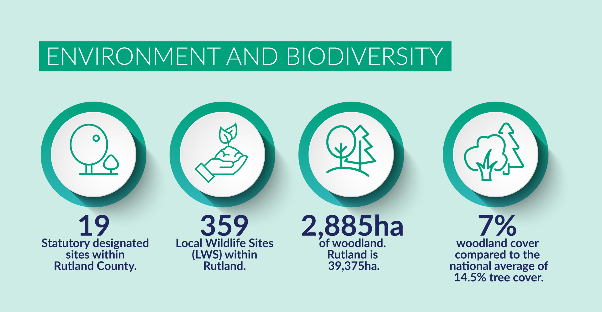
Green (vegetation) and blue (water) assets together form a network which brings a wide range ofbenefits in addition to the habitats they provide. Rutland has 19 Sites of Special Scientific Interest (SSSIs) including Rutland Water which, as an internationally important wetland for wintering and passage wildfowl, is also designated as a Special Protection Area (SPA) and Ramsar site. There are 284 local wildlife sites and important areas of calcareous grassland and ancient and broadleaved woodland in the County.
Irreplaceable habitats include heathland, ancient parkland, veteran trees, ancient semi-natural woodland and mature broadleaved plantation woodland, species rich and ancient hedgerows, species-rich grasslands, significant wetland systems and floodplains and natural watercourses.
Minerals extraction in particular has the potential to cause adverse impacts on the environment due to the nature of operations. It is essential therefore that due regard is given to the potential adverse impacts on the natural environment and appropriate avoidance and/or mitigation measures identified, or as a last resort, compensatory mitigation measures identified. Nevertheless, mineral extraction has the potential to also bring significant environmental benefits through site restoration. In all cases restoration should be sought in line with Policy MIN9 - Restoration and aftercare.
What you told us about the policy
Th issues and Options consultation showed that there was overall support (65% of respondents) for undertaking a mapping exercise to record a biodiversity baseline for Rutland and to identify locations for providing opportunities to improve biodiversity.
A biodiversity assessment for the whole of Rutland was completed in May 2023.
What alternatives we have considered
To retain existing policies from the adopted Local Plan (updated where needed) and rely on national policy.
Which existing policies will this policy replace?
CS21 – The Natural Environment
SP19 – Biodiversity and Geodiversity Conservation
Local Nature Recovery Strategies (LNRS)
What will this policy do?
This policy will ensure that development proposals that are not subject to mandatory Biodiversity Net Gain requirement will still be expected to make a positive contribution to the Local Nature Recovery Strategy.
(22) Policy EN2 - Local Nature Recovery Strategy
Development proposals will be expected to demonstrate that a positive contribution will be made to regional Nature Recovery Networks and the Local Nature Recovery Strategy and for maintaining or creating local ecological networks through habitat creation, protection, enhancement, restoration and/or management.
Why is this policy needed?
The Environment Act 2021 establishes a new mandatory system of spatial strategies for nature. Biodiversity Net Gain is likely to play a large part in ensuring strategies are delivered within local authority areas.
What you told us about the policy
This issue was not specifically raised in the Issues and Options consultation.
What alternatives we considered
No alternatives were considered; preparing a Local Nature Recovery Strategy is a requirement of the Environment Act 2021.
Supporting Evidence
Rutland County Biodiversity Assessment (May 2023)
Which existing policies will this policy replace?
This is a new policy. No current adopted planning policies in place with respect to local nature recovery.
Biodiversity Net Gain
What will this policy do?
This Policy will ensure that all major development will contribute towards delivering measurable net gains for nature so that biodiversity across the County as a whole is improved by the end of the Local Plan period, and the existing network of sites and habitats is protected and strengthened with the retention and creation of robust, well managed green infrastructure.
Biodiversity Net Gain will apply to all applications, except for householder and advertisements applications, and other minor developments where biodiversity considerations are not appropriate, e.g., a change of use from A1 (retail) to A3 (restaurants and cafes).
(51) Policy EN3 - Biodiversity Net Gain
Development will only be permitted for qualifying developments where a Biodiversity Net Gain of at least 15% is demonstrated and secured in perpetuity (for at least 30 years) subject to the following requirements:
- the latest DEFRA metric or agreed equivalent is used to quantify the biodiversity value of the site pre- development, post-development after application of the mitigation hierarchy and for any off-site areas proposed for habitat creation or enhancement both pre- and post-development.
- that the assessment be undertaken by a suitably qualified and/or experienced ecologist and is submitted together with baseline and proposed habitat mapping in a digital format with the application.
- a Biodiversity Gain Plan will be required, detailing how the post-development biodiversity values of the site and any supporting off-site provision will be secured, managed, and monitored in perpetuity.
- any off-site habitats created or enhanced are well located to maximise opportunities for local nature recovery.
- the proposed mitigation, compensation, and/or enhancement measures required to secure net gain for biodiversity are acceptable to the Council in terms of design and location, and are secured, on-site, for the lifetime of the development, or off-site for a minimum of 30 years, with appropriate funding mechanisms that are capable of being secured by condition and/or legal agreement.
Funding for both on-site and off-site measures shall include a payment to the Council to cover the costs of independent review of Biodiversity Gain Plans and long-term monitoring.
For minor developments, development will only be permitted where no net loss and appropriate net gain of biodiversity is secured using the latest DEFRA Small Sites metric or agreed equivalent.
Opportunities to secure Biodiversity Net Gain on householder developments and exempted brownfield sites will be supported.
* the Local Plan Viability evidence suggests that up to 20% biodiversity New Gain is viable and deliverable on sites in Rutland.
Policy Guidance on the requirements and processes for planning applications
The Council will expect developers to provide mitigation, compensation, and enhancement measures for biodiversity on, or immediately adjacent to, a site for all major development proposals (10 dwellings plus, 0.5ha or 1,000 sqm plus of floorspace, new build, or conversion or outline proposals capable of accommodating either), and where necessary and appropriate and in the interests of biodiversity, 'off-site' proposals will be considered acceptable. For such development on-site, mitigation, compensation, and enhancement measures will be the preferred option, but off-site will be considered where it offers the best outcome for biodiversity, is in reasonably close proximity to the application site, and follows the mitigation hierarchy.
Only that which cannot be mitigated or compensated for on-site will be permitted off-site, so even where off-site is agreed, on-site measures will still be required. Subject to forthcoming legislation provisions, a similar approach applies to non-major development, in a proportionate manner, also having regard to the most recent Metric and supporting Defra/Natural England Guidance. Prior to the adoption of an SPD, applicants are required to demonstrate a net gain in biodiversity through the application of the Defra Biodiversity Metric (or any subsequent replacement) and shall provide to the Council in support of an application a Biodiversity Gain Plan that includes:
- appropriate and up-to-date ecological surveys;
- an accurate, measurable plan of existing habitats as referenced in the metric;
- an accurate, measurable plan of proposed habitats as referenced in the metric;
- the metric calculations in their original form.
Where off-site is proposed through a scheme of biodiversity credits and/or land banking, that scheme and the location for the off-site measures will need to be approved by the Council, and evidence submitted to the Council to demonstrate compliance with Policy EN3 and any subsequent SPD.
All development proposals will be expected to demonstrate, through survey, assessment, and interpretation carried out by a suitably qualified professional, a comprehensive understanding of habitats and species associated with their site and adjacent land, and to provide an assessment of the likely effects. The assessment should be proportionate to the interests of the site and the likely effects of the proposal, and seek relevant information from the Rutland County Biodiversity Assessment (May 2023) and the Leicestershire, Leicester & Rutland Records Centre. It must be recognised that the DEFRA Biodiversity Metric is a proxy for biodiversity and does not cover all likely effects, and that professional judgment will be required to take account of issues outside the metric, including disturbance and connectivity.
Proposals for biodiversity and landscaping should be informed by national and local guidance, and strategies including Nature Recovery Plans. Current relevant guidance and information includes Rutland County Biodiversity Assessment (May 2023) and Biodiversity Action Plans. As part of net gains for nature, development will be expected to provide, protect, and reinforce green and blue infrastructure in accordance with Policy EN7 Green and Blue Infrastructure and to provide enhancements for biodiversity, to include where possible, but not limited to:
- bird and bat boxes selected and located in accordance with the advice of an ecologist, integrated into new buildings, and focused on garden and urban species, including crevice dwelling bats, swifts, house sparrows, and starlings
- wildlife friendly sustainable urban drainage (SuDs) features
- ponds and scrapes specifically designed for wildlife
- holes in fences for hedgehogs
- amphibian friendly kerbs/drains
- culverts under paths and roads for small mammals, reptiles, and amphibians
- wildlife friendly show gardens
- a scheme of wildlife talks and events for new residents
- bug boxes and bug hotels
- on-site interpretation panels of ecological features and habitats
Until such time as a SPD is adopted, reference will be made to the latest government guidance, Biodiversity Net Gain – Principles and Guidance for UK Construction and Developments (CIEEM, CIRIA, IEMA, 2016), British Standard BS42020 Biodiversity - Code of Practice for Planning and Development, and BS8683 - Biodiversity Net Gain or subsequent revisions.
Harm to irreplaceable habitats, including ancient woodland, should be avoided and they cannot be included in metric calculations for any gain or loss.
Any effects, either positive or negative, on ancient woodland will be considered in accordance with the Policy EN5 - Ancient woodland.
Why is this policy needed?
The Council has a legal duty to conserve biodiversity. A key role for the Local Plan is to ensure that future growth, especially in terms of housing and the economy, can take place without damaging the high-quality environment. If impacts are unavoidable then the Council must make sure mitigation is put in place to reduce any harm. This is particularly important in relation to the internationally protected habitats and species designations.
Government policy requires biodiversity net gain to be sought through planning policies and decisions. Biodiversity net gain should deliver measurable improvements for biodiversity by creating or enhancing habitats in association with development and can be achieved on or off site. One of provisions of the Environment Act (2021) is the mandatory requirement for new developments to provide 10% biodiversity net gain.
New evidence on biodiversity and wildlife for the County has been prepared. This evidence will provide the baseline against which Biodiversity Gain Plans for development proposals and the metric will be assessed. The biodiversity evidence covers the whole County and provides detailed information on existing habitat and species. The biodiversity study indicates that there is a paucity of biodiverse rich habitat in the County and opportunities to increase it should be identified. It recommends that the council seeks at achieve more than 10% net-gain wherever possible, however it does recognise that this might be difficult to achieve on-site in some cases where the sites is biodiverse rich. The Whole Plan Viability evidence considers the impact of requiring 20% biodiversity net-gain (as well as the national 10% requirement) and this demonstrates that the impact this higher requirement will have on viability is limited and should therefore be deliverable on all site typologies. The preferred policy approach is to require 15% net gain on site for all qualifying development proposals.
The Council will, consider providing further detailed guidance on this policy in the form of a Supplementary Planning Document which will set out the requirements for on-site and off-site net gain for:
- conservation objectives;
- long term management and monitoring;
- funding arrangements and costs for any local or strategic offsetting schemes. Requirements and processes for planning applications
What you told us
The Issues and Options consultation highlighted a need to ensure existing opportunities for biodiversity net gain and ecological enhancements are optimised. The consultation showed considerable support with 65% of respondents supporting a mapping exercise to record a biodiversity baseline for Rutland and to identify locations where there are opportunities to improve or restore existing wildlife habitat and create new habitat to strengthen the ecological network across the plan area.
What alternatives have we considered?
To review and update existing Local Plan policies to take full account of national planning policy and guidance, and the Environment Act.
Supporting Evidence
Rutland County Biodiversity Assessment (May 2023)
This provides a robust evidence base for the preparation of biodiversity and natural environment policies and proposals in the new Local Plan as well as informing a diverse range of other policy requirements such as Biodiversity Net Gain (BNG) Local Nature Recovery Strategies (LNRS), Green and Blue Infrastructure and climate change.
Which existing policies will be replaced by this policy?
This is a new policy. No current adopted planning policies in place with respect to local nature recovery.
Trees, Woodland, and hedgerows
What will these policies do?
The following policies will promote the retention and enhancement of existing trees, woodland, and hedgerow cover and encourage the exploration of opportunities for new tree planting as part of all development proposals.
(31) Policy EN4 – Trees, woodland, and hedgerows
Planning permission will only be permitted where the proposal does not adversely affect important trees, woodlands, and hedgerows, especially those that are:
- protected by a Tree Preservation Order; and/or
- in a conservation area; and/or
- ancient woodlands or ancient and veteran trees; and/or
- in historic parks and gardens; and/or
- within a recognised Nature Conservation Site; and/or
- important landscape or townscape trees; and/or
- making an important contribution to green infrastructure or other important ecological networks.
Improving Tree Cover
Major development will generally be expected to increase tree cover, and there will be a presumption in favour of the retention and enhancement of existing trees, woodland, and hedgerow cover on-site, unless:
- the removal of any trees would be in the interests of good arboricultural practice; or
- the need and/or public benefit of the proposed development outweighs the amenity value of any trees or hedges removed.
Planning permission will only be granted if the proposal provides evidence that it has been subject to adequate consideration of the impact of the development on any existing trees and woodland found on-site and on any trees off site which are visible from the site.
If any trees exist on or are visible from the development site, 'adequate consideration' is likely to include the submission of an Arboricultural Impact Assessment (AIA) and tree survey information in accordance with the current recommendations of BS 5837: Trees in Relation to Design, Demolition and Construction (or subsequent revision) The tree survey information should include protection, mitigation, and management measures, including arboricultural site supervision where required.
Mitigating for loss of Trees and Woodland
The loss of existing trees will only be allowed where there is clear evidence that its removal is unavoidable. In such cases the council will require at least 3 replacement trees for each tree lost. Replacement trees should be of a similar size and species to that which is being lost and will be required to be planted on-site. This does not necessarily replace the requirements of other policies with regard to biodiversity net gain or green and blue infrastructure but may contribute to those objectives.
New Trees and Woodland
Where appropriate and practical, opportunities for new tree planting should be explored as part of all development proposals (in addition to, if applicable, any necessary compensatory tree provision).
Planting schemes should:
- include provision to replace any plant failures within five years after the date of planting.
- consider the context of wider plans for nature recovery which seeks to increase biodiversity and green and blue infrastructure generally.
- try to connect areas of new planting with existing areas of tree cover to create wildlife corridors and increase biodiversity.
- only be carried out in appropriate locations that will not impact on existing ecology or opportunities to create alternative habitats that could deliver better enhancements for people and wildlife, including carbon storage.
- use a diverse range of species which are suitable for the location, using both native and non-native tree species.
Where woodland habitat creation is appropriate, consideration should be given to the economic and ecological benefits that can be achieved through natural regeneration.
Management and Maintenance
Appropriate management measures will be required to protect newly planted trees, woodlands, and/or hedgerows.
Deadwood within trees and woodland is important to biodiversity and ecology and should be retained wherever it is safe to do so.
Hedgerows
Proposals for new development will be expected to retain existing hedgerows where appropriate and integrate them fully into the design having regard to their management requirements.
Proposals for new development will not be supported that would result in the loss of hedges of high landscape, heritage, amenity, or biodiversity value unless the need for, and benefits of, the development clearly outweigh the loss and this loss can be clearly demonstrated to be unavoidable.
Where any hedges are lost, suitable replacement planting or restoration of existing hedges, will be required within the site or the locality, including appropriate provision for maintenance and management.
(24) Policy EN5- Ancient Woodland and Veteran Trees
New development is expected to protect and enhance irreplaceable habitats including ancient woodlands and ancient and veteran trees. Proposals which avoid or prevent the loss or deterioration of:
- ancient woodland; and/or
- the loss of aged, ancient or veteran trees found outside ancient woodland
will be supported, unless there are wholly exceptional circumstances, and a suitable mitigation and compensation strategy is provided.
Where historic parkland is identified, it shall receive the same consideration as other forms of ancient woodland.
Where development proposals may affect ancient woodlands, including translocated woodlands (translocated ancient woodlands will be treated the same as if they are ancient woodland), veteran trees, and their immediate surroundings, the following principles shall be used to guide both site selection and the design of development:
- avoidance of harm;
- provision of unequivocal evidence of need and benefits of the proposed development, and for the design of development:
- establishment of the likelihood and type of any impacts;
- implementation of appropriate and adequate mitigation, compensation, and management measures that respect the features and characteristics of the veteran trees and/or ancient woodland;
- provision of adequate buffers; and
- provision of adequate evidence to support development proposals.
Why are these policies needed?
Rutland County Council has a statutory duty (s197 of the Town and Country Planning Act 1990) to consider the protection and planting of trees when granting planning permission for proposed development.
There are various ways that trees may be protected, the most well-known being Tree Preservation Orders (TPOs). Protection is also afforded to trees in conservation areas, and trees may be protected in the short term by planning conditions. TPOs are made to ensure retention of individual trees, groups of trees, or woodland considered to be of amenity value, and any person who cuts down or damages a tree protected by a TPO is guilty of an offence for which they may be prosecuted and fined. In more rural areas, the felling of trees in woodlands is controlled by Forestry Commission Felling Licences, while the removal of certain agricultural hedges is controlled by the Hedgerows Act.
The NPPF (2023) promotes the need to contribute to and enhance the natural environment and recognise the wider benefits from natural capital and ecosystem services of trees and woodland[1]. Paragraph 131 states that trees make an important contribution to the character and quality of urban environments. Planning policies and decisions should ensure that new streets are tree-lined and that opportunities are taken to incorporate trees elsewhere in development.
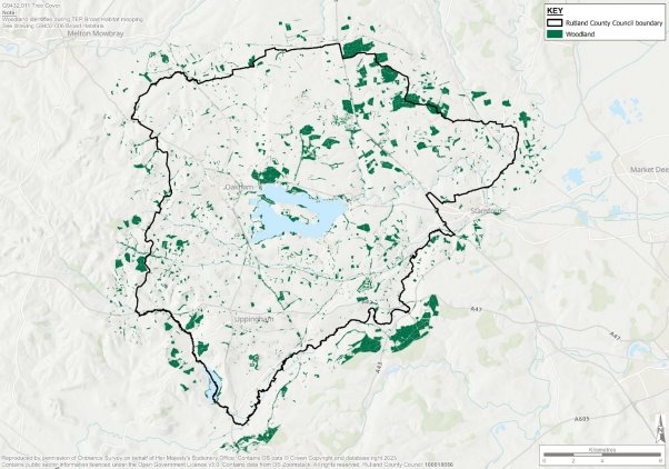
Whilst green and blue infrastructure accounts for 95% of our land cover in Rutland, our tree cover is low. Semi-natural broadleaved woodland accounts for only 2.09% of the land within the County, (822.23 ha), although plantation woodland covers a larger area (4.26% or 1,673.82 ha). The diagram below shows the woodland cover in Rutland (diagram from GBI report).
Figure 4
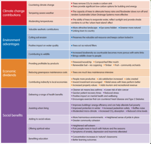
Trees have many benefits to landscape, wildlife, and the economy, so planting more trees is an important aspect of creating resilient and climate positive places and is a priority for Rutland.
Modest increases in tree canopy can make a significant contribution to climate change adaptation by reducing the urban heat island effect and improving air quality which often declines with higher temperatures. They also contribute to good water management and an increasingly important effect of trees is their ability to slow the flow of rainwater and reduce the risk of flooding. They contribute to other less tangible benefits; they absorb CO2 and help create a significant carbon sink by sequestering carbon through photosynthesis.
Trees absorb nitrates and phosphates[2] which are present in the soils of agricultural land and can have significant consequences to water quality. This overlaps with another priority for Rutland highlighted in the GBI study which is to enhance Rutland's water and soil quality[3].
The figure below summarises the wide-ranging benefits trees provide.
Figure 5
Planting more trees in Rutland is essential to provide these lasting benefits however it is also very important to consider how to protect existing trees. Consultation conducted in the production of the Green and Blue Infrastructure study concluded that the importance of tree retention over tree replacement was of significant importance.
Ancient Woodland
Ancient woods are areas of woodland that have persisted since 1600 in England, Wales, and Northern Ireland. They are relatively undisturbed by human development and as a result, they are unique and complex communities of plants, fungi, insects and other microorganisms[4]
The NPG[5] states that ancient woodland takes hundreds of years to establish and is defined as an irreplaceable habitat. It is a valuable natural asset important for:
- wildlife (which include rare and threatened species) - there is also standing advice for protected species
- soils
- carbon capture and storage
- contributing to the seed bank and genetic diversity
- recreation, health, and wellbeing
- cultural, historical and landscape value
Aged and veteran trees are those which, because of their great age, size or condition are of exceptional wildlife, landscape, or cultural value. Mature trees, woodlands and hedgerows are sensitive to the impacts of development, either directly through their removal or indirectly through the impacts of construction or the future use of the site. Due to the length of time and the cost taken to replace mature features, and the contribution they can make to the quality of development, they should be retained and protected wherever possible.
What you told us about the policy
Responses to the Issues and Options consultation highlighted the importance of tree planting as part of nature-based solutions to carbon saving measures through carbon capture and sequestration, as well as contributing to planted buffers, flood management, water efficiency, soil and water quality and health and well-being benefits.
65% of the responses to the consultation question on the options for the protection of green and blue infrastructure (GBI) showed support for development of a GBI strategy for the protection, enhancement, and management of the green and blue infrastructure network. This has been developed and identifies and maps the GBI assets of Rutland which includes tree cover. This evidence has strengthened the existing policy approach by developing a strategy to establish potential opportunities to protect and improve the management of green and blue infrastructure assets such as trees. This strategy has provided evidence for the development of this policy.
What alternatives have we considered?
The Green and Blue Infrastructure study (2023) highlights the strengths, weaknesses, opportunities, and challenges of green and blue Infrastructure in Rutland especially in relation to the low tree cover in Rutland. It makes several suggestions for how to improve the tree cover and the multi-functional benefits of doing this. The biodiversity report also evidences the low tree cover in Rutland and makes a policy suggestion from the evidence to combat this.
Which existing policies will these policies replace?
CS21 – The natural environment
CS23 - Green Infrastructure, open space, sport, and recreation
SP19 - Biodiversity and geodiversity conservation
Best and Most Versatile Agricultural Land
What will this policy do?
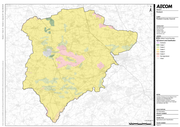
Agriculture is the predominant land use in Rutland, comprising over 75% of Rutland with specialist arable and pastoral farms, the primary function of which is food production. To sustain long-term food security and healthy soils in a changing climate, the protection of the best and most versatile (BMV) land is key to ensure that food production is not negatively impacted by development. Figure 6 shows the agricultural classification (ALC) within Rutland. Agricultural land classification maps are available on Natural England's web site Agricultural Land Classification Map East Midlands Region - ALC005 (naturalengland.org.uk) and on the Magic Map Application (defra.gov.uk)
Figure 6
(43) Policy EN6 - Protecting agricultural land
Planning permission for development which would lead to the loss of Grade 1, 2 and 3a agricultural land will only be permitted where:
- the land is allocated for development in the Local Plan; or
- it has been clearly demonstrated that there are no other more suitable and sustainably located sites available and that the needs for development are sufficient to override the need to protect Best and Most Versatile agricultural land.
- Grade 3 land may be permitted for Solar PV where the proposal meets the requirements of Policy CC8 - Renewable energy, however grade 1 and 2 will be ruled out for renewable energy use.
Why is this policy needed?
The NPPF requires Local plans to consider the economic and other benefits of the best and most versatile agricultural land (BMV). Where significant development of agricultural land is considered, the Council should seek to use areas of poorer quality land in preference to higher quality, subject to other sustainability considerations. 'A Green Future: Our 25-year plan to improve the Environment' sets out the government's 25-year plan to improve the health of the environment by using natural resources more sustainably and efficiently. It plans to protect the best agricultural land and put value on soils as part of our natural capital. They have set a target to manage soils in a sustainable way by 2030.
BMV Agricultural land is graded from 1 to 3a. The highest grade of land is that which:
- gives a high yield or output
- has the widest range and versatility of use
- produces the most consistent yield
- requires less input
Development of the best and most versatile agricultural land will only be supported where it can be demonstrated that the need for the development, its benefits and/or sustainability considerations outweigh the need to protect such land taking into account the economic and other benefits of the best and most versatile agricultural land.
The need to identify and maintain an appropriate supply of land for development creates some pressure for development of agricultural land despite a focus on bringing forward brownfield sites where possible.
Only a small part of the County is graded as Best and Most Versatile, however some of that land is located around the County town of Oakham and some Larger Villages, this makes identifying land for development challenging in this location and it may be that some BMV land is necessary to ensure that the need for homes and jobs can be met in a sustainable manner.
Green & Blue Infrastructure
What the policy will do?
Green and blue infrastructure (GBI) is a network of green spaces and water environments that sustains the ecosystems needed for a good quality of life.
Green and blue infrastructure (GBI) is critical to high quality environments and streetscapes, and it is important that new developments have well-designed GBI to enable Rutland to develop sustainably. GBI should be considered at the outset (pre-application stages) of new development proposals and green infrastructure principles should be incorporated into a scheme from the earliest stages of the design process. Developers should appraise the site context for green infrastructure functions and take opportunities to achieve multi-functionality by bringing green infrastructure functions together. New development should be capable of delivering a wide range of environmental, health and quality of life benefits for local communities.
The Green and Blue Infrastructure Network policy will conserve the existing GBI in Rutland and promote the opportunities for the creation of new high quality GBI.
(23) Policy EN7: Green and Blue Infrastructure Network
New development proposals should ensure that existing and new green and blue infrastructure (GBI) is considered and integrated into the scheme design from the outset. The functionality, accessibility and quality of existing open spaces should be reviewed and increased wherever this is possible.
Proposals that cause loss or harm to this network will not be permitted unless the need for, and benefits of the development demonstrably outweigh any adverse impacts. Where adverse impacts on GBI are unavoidable, development will only be permitted if suitable mitigation measures for the network are provided.
If damage or loss of existing green infrastructure is unavoidable, the creation of new or replacement GBI equal to or above its current value and quality, that maintains the integrity and functionality of the green infrastructure network will be required.
Where development is permitted, developers will be required to:
- retain and enhance existing on-site green and blue infrastructure (including water courses and ditches);
- put measures in place to ensure appropriate long-term management of any green and blue infrastructure directly related to the development (normally 30 years); and
- identify and provide opportunities to enhance and improve linkages between the natural and historical landscapes of Rutland.
Proposals for major development should be accompanied by an audit of the existing GBI within and around the site and a statement demonstrating how this will be retained and enhanced through the development process.
GBI projects and initiatives that contribute to the delivery of high quality and highly valued multi-functional GBI will be supported. The design and layout of new GBI projects should take opportunities to:
- incorporate a range of types and sizes of green and blue spaces, green routes and environmental features that are appropriate to the development and the wider green and blue infrastructure network to maximise the delivery of multi-functionality;
- deliver biodiversity net gain and support ecosystem services;
- support climate change adaptation and drought resilience including through use of appropriate habitats and drought resilient species; and
- encourage healthy and active lifestyles.
Development proposals must protect the linear features of the GBI network that provide connectivity between GBI assets, including public rights of way, bridleways, cycleways, and waterways, and take opportunities to improve and expand such features.
Contributions (financial or other) to support such projects and initiatives will be required where appropriate from developers towards the establishment, enhancement, and on-going management of green and/or blue infrastructure.
Why is this policy needed?
The NPPF requires local authorities to make every effort to promote healthy communities, meet the challenges of climate change and flooding and conserve and enhance the natural and historic environment through the planning process[6].
Planning Practice Guidance (PPG) sets out the value and benefits of open space, sports and recreation and the need to protect and enhance Public Rights of Way (PRoW)[7]. Green infrastructure helps absorb pollutants, including emissions from farmland, enabling better air quality. The PPG considers climate change and how a comprehensive approach to green infrastructure can promote better water efficiency and water quality. Green infrastructure can also reduce overall flood risk on development through sustainable drainage systems (SuDS), which can also deliver benefits for amenity, recreation, and wildlife.
The 25 Year Environment Plan sets out government action to help the natural world regain and retain good health. It aims to deliver cleaner air and water in the UK, protect threatened species and provide richer wildlife habitats. It calls for an approach to agriculture, forestry, land use and fishing that puts the environment first.
The National Planning Policy Framework[8] (NPPF, 2023) defines GBI as "A network of multi-functional green and blue spaces and other natural features, urban and rural, which is capable of delivering a wide range of environmental, economic, health and wellbeing benefits for nature, climate, local and wider communities and prosperity."
The types of GBI assets that make up the GBI network in Rutland, comprising both public and private green and blue spaces are:
- agricultural land
- allotments
- amenity open space
- grounds to public buildings
- grounds to religious buildings as well as stand-alone cemeteries
- parks and gardens
- private gardens
- sport facilities
- vegetation along transport corridors
- semi-natural habitats
- water: watercourses, canals, and reservoirs
- trees and woodland
People and nature benefit from a multitude of natural resources and processes that are dependent on ecosystem health. Benefits to people provided by nature have been termed 'ecosystem services' which are grouped into four broad categories:
- provisioning services, such as the production of food and clean water
- regulating services, such as managing the climate
- supporting services, such as nutrient cycles and crop pollination
- cultural services, such as recreational benefits
Figure 7
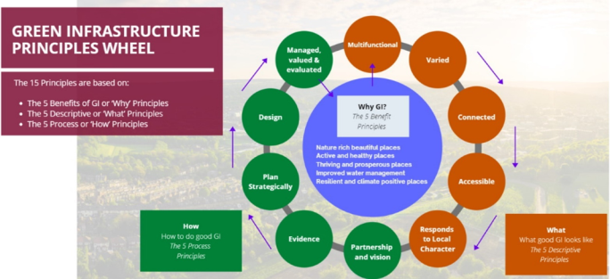
Figure 7 is taken from Natural England's Green Infrastructure Framework which provides a structure to analyse where greenspace in urban environments is needed most. The Green Infrastructure principles wheel outlines what good GBI looks like and the principles that should be followed to achieve this.
The Rutland Green and Blue Infrastructure Study sets out the green and blue infrastructure network and strategy for Rutland. It sets out the Rutland green and blue infrastructure vision which is "…host a well-connected, accessible and resilient network of green and blue infrastructure which brings multiple benefits to the environment whilst providing people with the opportunity to come into contact with diverse and nature-rich open spaces." Rutland County Council will work in partnership with landowners, businesses, and communities to deliver the GBI vision.
Rutland's top five GBI priorities in achieving this vision and the first step in making green and blue infrastructure at the core of our decision making are:
- restoring biodiversity and ecosystem integrity;
- protecting and enhancing tree cover;
- enhancing water and soil quality;
- incorporating GBI into new developments; and
- enabling active lifestyles and accessibility to GBI.
The Green and Blue Infrastructure Study maps the distribution of broad habitat types: agricultural, greenspace (or grassland), semi natural, water, woodland and non-GBI, Designated sites and opportunities for ecological connections. The green and blue infrastructure network can be viewed on the Rutland interactive map and within the Rutland GBI Study.
An Open Space Assessment was undertaken as part of the GBI study. It comprises of an assessment of the quantity, accessibility, quality, and value of open spaces within Rutland County and for each of the 15 sub-areas. The typologies of open spaces in Rutland are mapped. Local needs are identified, and the current and future provision of each sub area was reviewed. Local standards for open space provision and recommendations and based on the findings of this assessment were developed as part of this study. Policy SP7- Creation of New Open Space sets out how the requirements of new residential development of 10 dwellings or more to create new open space.
New Development
Green infrastructure is integral to developing new places, significantly contributing towards places where people want to live, work, and invest. The population of Rutland is projected to grow over the plan period, so creating thriving and prosperous places for Rutland's current and future residents is a key aspect of sustainable development. Development brings opportunities to enhance the network and deliver new green infrastructure of all types and sizes.
The NPPF recognises the opportunities that appropriately located and well-designed open spaces can provide. Paragraph 98 states "Access to a network of high-quality open spaces and opportunities for sport and physical activity is important for the health and well-being of communities and can deliver wider benefits for nature and supports efforts to address climate change."
New development should contribute to the extension of the green and blue infrastructure network, helping to address deficiencies in provision and providing good quality connections to the network and throughout the development. Open space should be provided on-site where possible. If the provision cannot be made on the application site an off-site location should be considered. In cases where the provision of open space cannot be met on-site the developer cannot provide an offsite location either, the council will seek developer contributions towards the costs of providing necessary facilities though developer contributions or the community infrastructure levy.
What you told us about the policy
The Issues and Options consultation asked the public's opinion on options for the protection of green and blue infrastructure. 65% of respondents supported the option to develop a GBI strategy for the protection, enhancement, and management of the GBI network in Rutland. This work was commissioned and is the evidence for the development of this policy.
Other comments highlighted the importance of the encouraging multifunctional GBI and the consideration of other benefits of GBI such as landscape value, health, heritage, climate mitigation and play. It is important to consider the various ecosystem services to ensure that new development supports the opportunities nature can provide. Many respondents stressed the importance of biodiversity conservation and expansion when discussing the GBI network of Rutland.
The theme of health and wellbeing came up many times in comments received in the consultation discussing ensuring that the community has access to leisure and recreational uses that are also sensitive to habitats and their management.
Comments recognised that when planned and delivered well GBI can provide benefits to everyone for the long term and play a vital role in placemaking.
What alternatives have we considered?
The Issues and Options consultation considered the alternative of continuing with the current policy approach however there was significant support for strengthening this approach with the development of a GBI strategy and discussed the many multifunctional benefits that well designed and managed GBI can provide.
Which existing policies will be replaced by this policy?
CS21 – The natural environment
CS23 - Green infrastructure, open space, sport, and recreation
CS24 – Rutland Water
SP15 – Design and amenity
SP19 - Biodiversity and geodiversity conservation
Important Open Spaces and Frontages
What will this policy do?
The policy prevents adverse impacts on designated Important Open Spaces and/or Frontages which contribute to the character of settlements in Rutland.
(21) Policy EN8 Important open space and frontages
Development will only be acceptable where it does not have an adverse impact on an Important Open Space and/or Important Frontage as shown on the policies map having regards to:
- its intrinsic environmental value by virtue of its landform, vegetation or tree cover, or the presence of any special features such as streams, ponds, important wildlife habitats or walls;
- its contribution to enhancing the attractiveness of the town or village setting when viewed from surrounding land, particularly the approaches to the built-up area;
- the views and/or vistas out of and within the town or village that contribute to the character and attractiveness of the settlement;
- its peripheral or transitional open character in contributing to preserving the form and character of the settlement including heritage assets;
- its contribution, possibly in conjunction with other areas, to creating the overall character and attractiveness of the settlement;
- its contribution to the form and character of the settlement in terms of the relationship of buildings and structures one to another, to other open spaces or natural features; and
- its contribution to the setting of a building or group of buildings or important natural features.
Some areas of Important Open Space are protected by their type and are not shown in the Policies Map. These Important Open Spaces are:
- sports centres/recreation grounds;
- cemeteries;
- churchyards;
- school playing fields;
- Local Authority owned allotments;
They will be safeguarded from development, and any proposal for their loss will be considered against the criteria above and against national policy.
Why is this policy needed?
Open spaces and frontages are an integral part of the built environment of settlements and add to the rural character of the market towns and villages by affording views into the countryside, providing the setting and relationship between buildings, and providing openness to the settlement. These open spaces also add to the distinct character of a settlement and their removal could dramatically alter the character and setting of buildings of a village or town. It is therefore important that the value of these open spaces is safeguarded. This Local Plan protects existing Important Open Spaces and Frontages (IOSF) which have been identified by Rutland County Council as important to the settlement in which they are located.
The NPPF advises that access to high quality open spaces can make an important contribution to the health and well-being of communities and should not be built on unless they are surplus to requirements, the loss would be replaced by better provision, or the development is for alternative sports and recreation provision.
Important frontages can include stone walls, high hedges, and a belt of trees or other features of significance to the character of an area or settlement. Their disruption would often adversely affect this character and their retention is therefore important. Sites were identified in the Review of Important Frontages and Open Spaces (2012 and 2017) and are mapped on the policies maps.
A number of settlements in Rutland have prepared Neighbourhood Plans, some of these contain designations for Important Open Space or an equivalent. These open spaces have not been duplicated as part of this policy, as they have their own protection through the Neighbourhood Plan in which they are designated.
Local Green Space
What will this policy do?
A local green space is a designated area of green or open space that is demonstrably special to the local community that it serves. This policy will protect areas with a Local Green Space designation from development apart from in very special circumstances. These exceptions are set out in the NPPF and align with Green Belt status. The Local plan does not identify any Local Green Spaces, however a number of Neighbourhood Plans to designate LGS and the policy will protect these sites accordingly.
(10) Policy EN9 –Local Green Spaces
An area identified as a Local Green Space within an adopted Neighbourhood Plan will be protected from development in line with the NPPF, which rules out development on these sites other than in the very special circumstances set out in the NPPF.
Why is this policy needed?
Local Green Space (LGS) is a national designation, as referenced in the NPPF[9], which aims to protect green areas or spaces which are demonstrably special to a local community and hold a particular local significance. Parish and Town Councils, through Neighbourhood Plans, can identify green areas of particular importance to them for special protection as Local Green Spaces. LGS designation can be used where there is evidence which demonstrates the green space meets the following criteria:
- it is in reasonably close proximity to the community it serves
- it is demonstrably special to a local community and holds a particular local significance, for example because of its beauty, historic significance, recreational value (including playing fields), tranquillity or richness of its wildlife
- it is local in character and scale and not an extensive tract of land
Additionally, the green space should-
- not already subject to a planning permission or an adopted local plan allocation
- not already protected by another designation or strategic planning policy
- be physically or visually accessible in some form
Planning permission will only be granted for development proposals on LGS in very special circumstances. These exceptions are set out in the NPPF and align with Green Belt status.
When Neighbourhood Plans are being prepared or reviewed, consideration may be given to the designation of green space which are of particular importance to the community for special protection as Local Green Spaces. Proposals for the designation of a site as an LGS must meet the criteria set out above.
Rutland Water
What will this policy do?
The Rutland Water Area designation provides special protection for Rutland Water and Policy EN10 sets out the overall approach to development around Rutland Water. This permits small scale development within the five defined recreation areas and the wider Rutland Water area for certain specified uses related to the enjoyment of Rutland Water or for operational uses.
A wider "Rutland Water Area" is also defined comprising the reservoir and its immediate surroundings where small-scale new recreation, sport and tourist facilities developments are limited to those essential for nature conservation or fishing or essential for operational requirements of existing facilities and subject to requirements in terms of location, scale, design, and landscape impact.
Camping and caravanning activities are seen to be potentially damaging to the character and setting of Rutland Water and are not permitted in the wider Rutland Water Area nor in the defined Barnsdale or Whitwell Recreation Areas.
(18) Policy EN10 - Rutland Water Area
Development in the area defined on the Policies Map as the Rutland Water Area should be carefully designed and located to ensure that it respects the nature conservation features of this internationally important site and does not have an adverse impact on the landscape and wildlife interests and the general tranquil and undisturbed environment of Rutland Water.
The Council will support proposals which involve the function and operation of Rutland Water Reservoir, its treatment works, associated networks and supporting infrastructure within the defined Rutland Water Area subject to the criteria below.
New development will be limited to small scale recreation, sport and tourist uses or essential for Anglian Water operational requirements within the five defined Recreation Areas only. These areas are defined on the Policies Map.
In all cases the applicant must demonstrate that the development within the designated Recreation Areas would:
- be in keeping with its surroundings in terms of its location, scale, form, and design and would not detract from the appearance of the shoreline and setting of Rutland Water;
- be compatible with other uses of land and leisure activities;
- not be detrimental to the special nature conservation interests of Rutland Water (including the conservation objectives for the RAMSAR site, Special Protection Area and Site of Special Scientific Interest and the requirements of the Habitats Regulations);
- not be detrimental to local amenity including the level of traffic movements and, parking in the Rutland Water Area not having a severe adverse impact on road safety or amenity; and
- not be detrimental to highway considerations.
New construction should be modest in scale and existing buildings utilised wherever possible and appropriate, particularly those of architectural or historic interest or of environmental value.
Outside the five defined recreation areas, new development will only be acceptable where it is demonstrated that it is essential for nature conservation or fishing or essential to the operational requirements of existing facilities, subject to it being appropriate in terms of location, scale, design, and impact on the landscape, SSSI/SPA/ Ramsar designations and biodiversity.
Caravan and camping sites will only be acceptable within the defined recreation areas of Sykes Lane, Normanton, and Gibbet Lane where appropriate to the area in terms of its scale, location, and impact on the surrounding area.
Minerals development, which is likely to have an unacceptable adverse impact on the environmental and recreational value of Rutland Water and its setting and the supply of water from the reservoir, will not be permitted unless the reasons for development outweigh the likely adverse impact, taking into account the requirements of relevant legislation and guidance.
Why is this policy needed?
Rutland Water is an important reservoir providing water supplies to the East Midlands and areas to the south and east. It is an internationally important site for nature conservation with a major role as a recreational facility with importance for tourism and the local economy.
The reservoir and its immediate surrounds have been designated a Site of Special Scientific Interest, a RAMSAR site and Special Protection Area with national and international importance for passage and breeding waterfowl. As such, it receives statutory protection, and any development will be subject to strict controls to ensure that it does not adversely affect the integrity of the site.
It also plays a major role in providing recreational activities, of both a passive and active nature, such as sailing and water sports, walking, cycling, bird watching, fishing, and picnicking and it is recognised that some limited development may be needed to support this role.
The NPPF requires that planning policies should recognise the hierarchy of international, national, and locally designated sites of importance for nature conservation. It also seeks to promote a strong rural economy by supporting the sustainable growth and expansion of rural business. This includes supporting rural tourism and leisure developments that benefit businesses in rural areas, communities, and visitors and which respect the character of the countryside.
The policy approach to the area around Rutland Water has been largely successful since the 1970's in protecting nature conservation interests of the reservoir and retaining the unspoilt and tranquil nature of the area, while accommodating recreation and tourism needs.
A Landscape Review of the Rutland Water Area (2019) was undertaken to provide robust up-to-date evidence to underpin the identification of the Rutland Water Area and its boundaries, and the Recreation Areas inset within it, as required by the NPPF. The study provides the evidence and reasoned justification to support the identification of the Rutland Water Area in the Local Plan as a 'valued landscape'.
The Rutland Water Area designation provides special protection for Rutland Water. Within the defined Rutland Water Area (RWA) around the reservoir and its immediate environs, strategic policy allows for carefully managed limited development of certain specified uses carefully designed and located to ensure that it respects the nature conservation features of this internationally important site and does not have an adverse impact on the landscape and wildlife interests and the general tranquil and undisturbed environment of Rutland Water. Small scale recreation, sport and tourist uses are permitted within five defined Recreation Areas (RAs) around the shores of the reservoir within the RWA where this is directly related to the use and enjoyment of Rutland Water or for operational uses (by Anglian Water) and appropriate in scale, form, and design to its location.
The whole of the Rutland Water Area including the defined Recreation Areas is also within the countryside as defined in the Local Plan and will be subject to policies relating to development in the countryside.
What you told us about the policy
This issue was not specifically raised in the previous consultation.
Which existing policies will this policy replace?
CS24 – Rutland Water
SP26 – Rutland Water Recreation Area
Eyebrook Reservoir
What will this policy do?
Policy EN11 sets out the criteria that will apply to help protect the nature conservation interests and the setting and the shoreline of the reservoir and other considerations. The Council also recognises the need to co-ordinate policy and site management with Harborough District Council in Leicestershire to ensure a complementary approach is secured for the wider Eyebrook Reservoir Area.
(7) Policy EN11 - Eyebrook Reservoir Area
Only small-scale recreation, sport and tourist facilities will be acceptable at Eyebrook Reservoir subject to them being closely associated with the existing leisure activities of the area and not detracting from the setting and shoreline of the reservoir and environmental, amenity and highway considerations.
Development must not be detrimental to the special nature conservation interests of Eyebrook Reservoir (including the conservation objectives for the Site of Special Scientific Interest and Regionally Important Geological Site).
Caravan and camping sites will not be permitted.
Why is this policy needed?
Eyebrook Reservoir lies on Rutland's southern border and straddles the boundary with Leicestershire County and Harborough District Councils. It is designated as a Site of Special Scientific Interest and therefore has statutory protection.
What you told us about the policy
This issue was not specifically raised in the previous consultation.
Historic and Cultural Environment
What will this policy do?
Heritage assets play an important part in the local character and identity of the County. National policy for heritage is prescriptive and requires the protection and enhancement of heritage assets and their settings. There is no need to repeat national policy in the Local Plan so policy EN12 sets out how national policy will be implemented in Rutland; it establishes what supporting evidence will be required and how development proposals are expected to be designed and developed to take heritage assets into account and sets out support for appropriate renewable energy proposals involving heritage assets.
(21) Policy EN12 - The historic and cultural environment
All development proposals, projects and activities will be expected to protect, conserve and where possible, seek opportunities to enhance historic assets and their settings, maintain local distinctiveness and the character of identified features.
Development should also respect the historic landscape character and contribute to its conservation, enhancement or restoration, or the creation of appropriate new features.
Development proposals affecting or likely to affect any heritage assets or its setting will be expected to demonstrate an understanding of the significance of the asset and/or its setting by describing it in sufficient detail to determine its historic, archaeological, or architectural interest to a level proportionate with its importance. A Historic Impact Assessment may be required to support proposals which affect historic assets and their setting.
As a minimum this should be through reference to the Historic Environment Record or by a desk-top analysis and reference to other relevant sources of information, which may include landscape character and historic landscape character appraisals, conservation area appraisals and management plans.
Desk based and/or field evaluations may be required to identify and determine the nature of the asset, describe the significance of the asset and its setting and any potential impacts resulting from the proposed development, as well as to inform the identification of appropriate avoidance and/or mitigation measures required to minimise impacts to an acceptable level (appropriate to their significance).
Locally sourced, sustainable, building and roofing materials will be used in the repair and maintenance of historic buildings and structures where appropriate.
The adaptive re-use of redundant or functionally obsolete listed buildings or important buildings will be supported where this does not harm their essential character.
Appropriate proposals for energy efficient and renewable energy measures for historic buildings, which adequately safeguard their heritage significance, will be permitted.
Why is this policy needed?
One of the core land use principles established in the NPPF is that planning should conserve heritage assets in a manner appropriate to their significance so that they can be enjoyed for their contribution to the quality of life of this and future generations. The guidance is set out in the NPPF (paragraphs 188-208).
Heritage assets include designated assets that are protected under relevant legislation and other non-designated features that have been identified locally, as set out below:
Designated features:
- listed buildings;
- scheduled monuments;
- registered parks and gardens;
- conservation areas.
Non-designated features:
- areas of archaeological interest;
- buildings of local importance;
- open spaces;
- parkland;
- other features of importance to the historic environment identified in the Historic Environment Record
These heritage assets play an important part in the local character and identity of the County.
Rutland has a rich built and historic environment with many attractive stone-built villages and two historic town centres that provide a distinctive local character to the area. There are 34 designated Conservation Areas, 16 Article 4 Directions and approximately 1,650 listed buildings that are afforded statutory protection and two Registered Parks and Gardens at Burley Park and Exton Park.
It is important that both designated and non-designated heritage assets are recognised and protected and wherever practical enhanced by development. A list of designated heritage assets in Rutland is shown in Appendix 4. There is an online register of all listed buildings on the Historic England website: https://historicengland.org.uk/listing/the-list/
Scheduled monuments, Registered Parks and Gardens and Conservation Areas are shown on the Policies Map, they are also available online on our Environmental Constraints interactive map.
The Historic Environment Record is a comprehensive database of historic buildings and areas of archaeological interest in Rutland that is maintained on behalf of the Council by Leicestershire County Council, and this should be consulted in order to establish whether development proposals are likely to affect heritage assets.
There is also a range of other information including the Leicestershire, Leicester and Rutland Historic Landscape Characterisation Project that should be consulted as appropriate in order to establish any potential impacts on the historic environment.
What you told us about this topic
Strategic Objective 9 in the Issues and Options consultation established the objective of protecting and enhancing Rutland's environment, inclusive of the rich historic built environment. 46% of respondents said they agreed with refreshing and updating local policy to be in line with the NPPF. The Issues and Options consultation also highlighted a need to ensure that the support for sympathetic upgrading of Listed Buildings and historic assets to become more energy efficient and sustainable.
What alternatives have we considered?
One alternative was to resource the updating of the historic environment evidence base including conservation area management plans and appraisals and identified assets of local historic importance.
Which existing policies will be replaced by this policy?
CS22 – The historic and cultural environment
Protecting Heritage Assets
What will this policy do?
Rutland is a unique place with a wide variety of important historical features, this policy sets out the means of achieving the overarching objective of conserving the historic and heritage assets within Rutland. Through identifying the different types of assets and the requirements in which they are approached through any proposed development.
(19) Policy EN13: Protecting heritage assets
- Designated heritage assets
The Council will apply national policy to development proposals which affect designated heritage assets. This includes Listed Buildings, Conservation Areas, and Scheduled Monuments. National policy for designated assets will also be used to consider development proposals which affect the setting of designated assets.
- Conservation Areas
Significant weight will be given to the protection and enhancement of Conservation Areas (as defined on the Policies Map). Development within, affecting the setting of, or affecting views into or out of, a Conservation Area should conserve, or where appropriate enhance, features that contribute positively to the area's special character, appearance and setting, including as identified in any adopted Conservation Area appraisal. Proposals should:
- retain buildings/groups of buildings, existing street patterns, historic building lines and ground surfaces and architectural details that contribute to the character and appearance of the area;
- where relevant and practical, remove features which have a negative impact on the character and appearance of the Conservation Area;
- retain and reinforce local distinctiveness with reference to height, massing, scale, form, materials, and plot widths of the existing built environment;
- assess, and mitigate against, any negative impact the proposal might have on the townscape, roofscape, skyline and landscape; and
- aim to protect trees, or where losses are proposed, demonstrate how such losses are appropriately mitigated against.
- Archaeology
Development affecting archaeological remains, whether known or potential, designated, or undesignated, should take every practical and reasonable step to protect and, where possible, enhance their significance. Planning applications for such development should be accompanied by an appropriate and proportionate assessment to understand the potential for and significance of remains, and the impact of development upon them. If initial assessment does not provide sufficient information, developers will be required to undertake field evaluation in advance of determination of the application. This may include a range of techniques for both intrusive and non-intrusive evaluation, as appropriate to the site.
Wherever possible and appropriate, mitigation strategies should ensure the preservation of archaeological remains in-situ. Where this is either not possible or not desirable, provision must be made for preservation by record according to an agreed written scheme of investigation submitted by the developer and approved by the planning authority. Any work undertaken as part of the planning process must be appropriately archived in a way agreed with the local planning authority.
Development proposals that would result in the removal or destruction of remains of archaeological interest that are considered to be of equal significance to a scheduled monument will not normally be permitted.
Development that would adversely affect other important archaeological remains will only be acceptable where:
- the benefits of the development outweigh the harm to the remains and the value of retaining the remains in situ; and
- the degree of disturbance has been minimised; and
- satisfactory provision is made for the evaluation, excavation, recording and interpretation of the remains before the commencement of development.
Where development can take place and still preserve important features in situ, planning conditions will be sought to secure the implementation of effective management plans that ensure the continued protection of those features.
- Buildings of local importance/non-designated heritage assets
Development that has the potential to affect a non-designated heritage asset (for example Ridge and Furrow landscape) will be considered having regard to the scale of any harm or loss and the particular significance of the heritage asset and its setting.
Where planning permission is required, which would involve the demolition of, or substantial alteration to, the external appearance of any building designated as being of local importance will only be allowed where it is demonstrated that:
- all reasonable steps have been taken to retain the building, including examination of alternative uses compatible with its local importance; and
- retention of the building, even with alterations, would be demonstrably impracticable; and
- the public benefits of the scheme outweigh the loss of, or substantial alteration to, the building.
- Re-use of historic buildings
The conversion or change of use of a statutorily protected or locally listed building or structure which makes a significant historical, cultural, or architectural contribution to the character of the area will only be acceptable where:
- a structural survey demonstrates that the conversion or change of use can be undertaken without extensive building works, alterations or extensions that would have a significant detrimental effect on the structure's character and appearance;
- the proposal can be achieved in a way that preserves the structure's historic, cultural, and architectural features and its character;
- the nature, scale and intensity of the proposed use are compatible with, and would not prejudice, surrounding uses or the character of the locality; and
- it would not adversely affect protected species or habitat.
Wherever possible, the building or structure should remain in the use for which it was originally designed. Where this is not possible, employment, recreation or tourism uses (including holiday accommodation for short stay occupation on a rented basis) will be the next preference.
Conversion to residential uses will only be acceptable where employment, recreation or tourism uses of the building are shown to be unviable.
Why is this policy needed?
The Council has carried out conservation area appraisals for a number of villages in Rutland. These identify and explain how the special interest of such areas will be preserved and enhanced and identify buildings of local importance in these villages. Appraisals will be undertaken and reviewed over time, and management plans prepared for the remainder of the conservation areas to monitor change and identify opportunities for enhancement.
Sixteen Article 4 Directions have been made within Rutland these introduce tighter controls within conservation areas and other sites or areas of heritage importance to control certain types of permitted development which, if unchecked, would cause harm to the special character and appearance of such areas. Neighbourhood Plans offer a further opportunity for local communities to identify the unique historic character of their settlements; identify key local building styles and characteristics which can inform and guide new development proposals and include the identification of locally important non designated heritage assets.
Other measures for preserving or enhancing heritage assets may include:
- actions to ensure the proper conservation of all heritage features that are at risk
- the maintenance and repair of heritage assets
In 2019 the following features were identified by Historic England as being at risk in Rutland and the Council will consider measures to ensure that these are protected and enhanced as appropriate:
- Old Hall Ruins (Exton)
- Oakham Castle Walls (n.b. works to restore the walls have now been completed)
- Church of St Mary, Greetham
- Church of St Mary, Cottesmore Road, Ashwell
Historic England's Register only covers Grade I and Grade II* Listed Buildings, Grade II listed places of worship across England. Authorities are expected to maintain their own register for Grade II listed buildings.
The Council will support the supply of locally sourced building materials where necessary for conservation purposes such as the repair and maintenance of historic buildings and structures in Rutland.
The NPPF provides national policy for considering proposals which affect a heritage asset. This includes the need to assess the effect of a proposal on the significance of an asset and the need for a balanced judgment about the scale of any harm or loss and the significance of the heritage asset.
What you told us about this topic
Strategic Objective 9 in the Issues and Options consultation established the objective of protecting and enhancing Rutland's environment, inclusive of the rich historic built environment. 46% of respondents agreed with refreshing and updating local policy to be further in line with the NPPF. The Issues and Options consultation also highlighted a need to ensure that the support for; sympathetic upgrading of Listed Buildings and historic assets to become more energy efficient and sustainable.
What alternatives have we considered?
One alternative option to this strategic policy was to consider the wider use of Article 4 Directions (which can be used to remove some development rights) to help control the erosion of an area's heritage and character, however this was a less favoured option through Issues and Options.
[1] NPPF (2021) Paragraph 174 - https://www.gov.uk/guidance/national-planning-policy-framework/15-conserving-and-enhancing-the-natural-environment
[4] https://www.woodlandtrust.org.uk/trees-woods-and-wildlife/habitats/ancient-woodland/
[5] https://www.gov.uk/guidance/ancient-woodland-ancient-trees-and-veteran-trees-advice-for-making-planning-decisions#ancient-woodland
[6]https://assets.publishing.service.gov.uk/government/uploads/system/uploads/attachment_data/file/1005759/NPPF_July_2021.pdf
[7] https://www.gov.uk/guidance/open-space-sports-and-recreation-facilities-public-rights-of-way-and-local-green-space
[9] Para, 100, NPPF (2021) https://www.gov.uk/guidance/national-planning-policy-framework/8-promoting-healthy-and-safe-communities#para100