
Main Modifications Consultation
Chapter 6. Housing
MM25 View representations
Page 82
Para/Table/Box/Policy
H1
Proposed Modification
Amend policy text to read:
Policy H1 – Sites proposed for residential development
Provision is made in this Local Plan for the delivery of at least 123 homes per annum with an additional 10% allowance for flexibility. The Plan therefore makes provision for 2705 new dwellings distributed in accordance with the spatial strategy in Policy SS1.
The Local Plan meets the minimum housing requirement of 123 dwellings per annum (totalling 2,460 dwellings over the plan period), as set out in bullet 1 of Policy SS1 and derived from the Government’s Standard Method. The Council is seeking to make provision for approximately 10% more than this requirement, resulting in a planned housing supply of 2,705 dwellings. This planned supply is intended to provide flexibility, support delivery and ensure the minimum requirement is met, and is distributed in accordance with the spatial strategy in Policy SS1.
Amend Table to read:
|
Location |
|
Completions and commitments since 31/03/2021 |
Residual requirement |
Delivery Mechanism |
|
Oakham with Barleythorpe |
820 |
|
|
Local Plan |
|
Uppingham |
515* |
20 |
31 |
Neighbourhood Plan |
|
Stamford North |
650 |
0 |
650** |
Local Plan/Planning Application |
|
Larger Villages |
620 |
|
|
Local Plan |
|
Small villages |
100 |
84 |
16 |
Local Plan |
|
County total |
2705 |
1 |
|
*This is a minimum requirement rather than a supply figure.
Insert footnote next to the 650 at Stamford North in the table to read
** It is intended that any development on the Rutland part of a comprehensive Sustainable Urban Extension to Stamford should count towards Rutland's housing needs and so reduce the requirement for new housing elsewhere in Rutland. It should also be noted that the Housing Trajectory based on a base date of 1st April 2025 shows that only 583 dwellings are to be delivery in the plan period. This also applies to the table in Policy H1.
.....
Uppingham Total: 3141 dwellings
To be allocated through the Uppingham Neighbourhood Plan. This figure
is a requirement and not the total supply of dwellings provided for via the
the Neighbourhood Plan.
Reason
For clarity and to be clear that the figures in the table relate provision/supply and that the figure for Uppingham is a requirement and supply.
MM26 View representations
Page 82
Para/Table/Box/Policy
H1 – Paragraph 6.5
Proposed Modification
Amend paragraph to read:
The proposed supply of housingdistribution of housing provision for this Local Plan is set out belowin Policy H1, including a 10% buffer. It is proposed to apply a contingency buffer of 10% to ensure delivery of the minimum housing requirement. This will also provides for a level of market choice, to support delivery.
Reason
For consistency related to other modifications to Policy H1
MM27 View representations
Page 82
Para/Table/Box/Policy
H1 – Table 3
Proposed Modification
Delete Table 3
Table 3 – Housing Requirement
|
|
|
|
|
|
|
|
|
|
|
|||
|
|
|
|
|
|
|
|
|
|
|
|
|
|
|
|
|
|
|
|
|
|
|
|
|
|
|
|
|
|
|
|
|
|
|
* These figures will be reviewed and updated on a regular basis during the preparation of
the Local Plan.
** It is intended now that any development on the Rutland part of a comprehensive
Sustainable Urban Extension to Stamford should count towards Rutland’s housing needs
and so reduce the requirement for new housing elsewhere in Rutland.
Reason
To prevent duplication with the table in Policy H1
MM28 View representations
Page 82
Para/Table/Box/Policy
H1
Proposed Modification
Amend text at paragraph 6.7 and add two new paragraphs to read:
The NPPF states that the overall strategic housing requirement policy in the Local Plan should set out a housing requirement for designated neighbourhood plan areas which reflects the overall strategy for the pattern and scale of development and any relevant allocations. Therefore, this Local Plan establishes the strategy for the pattern and scale of development (in Policy SD2) and has allocated suitable and deliverable sites in settlements across the County (excluding Uppingham) and the proposed allocations included in this Plan are considered to meet that requirement. For Uppingham, the figure of 515 dwellings forms part of the spatial distribution of development under Policy SS1 and does not constitute a separate housing requirement for the Neighbourhood Plan area.
The housing requirement of 515 dwellings for Uppingham is derived from the spatial distribution of the Local Plan housing requirement and forms the starting point for assessing housing delivery in the town over the plan period. The figure of 314 dwellings represents the residual housing requirement, calculated by deducting dwellings that have been completed or are committed in Uppingham since the start of the plan period from the overall requirement of 515 dwellings. In accordance with national policy and the spatial strategy of the emerging Local Plan, this residual requirement is intended to be met through policies and site allocations in the Uppingham Neighbourhood Plan.
The Neighbourhood Plan has been prepared in alignment with the Local Plan and provides the mechanism by which the residual requirement arising from the 515‑dwelling minimum is delivered, through the identification of sufficient housing supply in appropriate and sustainable locations within the town. Housing delivered through the Neighbourhood Plan contributes to the overall housing supply for Rutland and is reflected in the county‑wide housing land supply position, which is monitored and reported annually in accordance with national policy, as set out in the Housing Land Supply section below. The housing supply identified for Uppingham is therefore assessed against the residual housing requirement.
Reason
To clarify that the figure for Uppingham in H1 is a requirement not supply.
MM29 View representations
Page 82
Para/Table/Box/Policy
H1
Proposed Modification
Amend text at paragraph 6.14 and add two new tables and new supporting text to read:
Development principles to guide the form, layout, dwelling mix (for housing allocations), and infrastructure needs of each allocated site are set out in H1.1 – H1.4below and in policy H2.
Housing Land Supply
The housing supply position will be monitored annually, in order to ensure that a deliverable five-year supply of housing sites with an additional buffer is maintained in Rutland. An annual report will be published every year to set out the Council’s position against the (adopted) housing requirement for the County which identifies the deliverable supply to establish the number of years which are available.
Paragraph 77 of the National Planning Policy Framework (NPPF 12/23) includes a requirement for local planning authorities to identify and update annually a supply of specific deliverable sites sufficient to provide five years’ worth of housing land when assessed against their housing requirements.
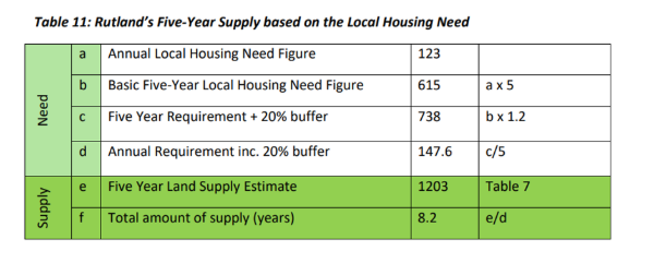
As the Rutland Local Plan was submitted for examination under the transitional arrangements set out in NPPF 12/24, the standard method for calculating Local Housing Need (LHN) provides a minimum housing requirement for Rutland of 123 dwelling per annum, which equates to a five-year local need figure of 615 dwellings. Based on the most recent Housing Delivery Test in 2023, Rutland has gone below the delivery requirement of at least 85%, at 80% over the past three years and therefore the 20% buffer for persistent under delivery does now apply.
The table below demonstrates the Council has a five-year housing land supply for the five-year period from the adoption date of the Local Plan (at end 24/25), for the period 2026/27 to 2030/31.
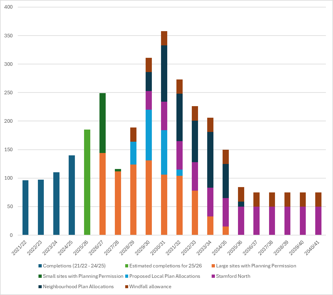
Furthermore, the Local Plan identifies a total supply of 3,150 for the plan period, it is recognised that this higher than the planned housing provision of 2,705 set out in Policy H1. Providing this additional supply allows the Council to provide flexibility and resilience to ensure the minimum requirement can be met. Table 3 below shows how the supply of 3,150 is forecast to be delivered during the plan period, up to 2041.
Insert new table:
Table 3 – Housing Land Supply Calculation
Spatial Distribution of Housing Land Supply
The table below compares the planned spatial distribution of housing set out in Policy H1 with the expected distribution of housing supply over the plan period 2021–2041, based on the housing trajectory. It provides a clear illustration of how the spatial strategy will be delivered in practice.
Insert new table:
Table 4 – Spatial distribution of Housing Land Supply
|
Proposed target spatial distribution |
Total supply 2021-2041 |
|
|
Stamford North |
650 |
583 |
|
Oakham |
820 |
832 |
|
Uppingham |
515 |
643 |
|
Larger Village with PLD |
620 |
701 |
|
Small villages/ hamlets (without a PLD) |
100 |
81 |
|
Total supply exc. Windfall/Lapse Rate |
2705 |
2840 |
|
Windfall |
325 |
|
|
Lapse rate |
-20 |
|
|
Total supply |
3145 |
The comparison shows that, while overall housing delivery will exceed the minimum requirement and planned provision, the distribution of development does not align exactly with the proportions set out in Policy H1. In particular, a greater proportion of development is expected to come forward in Uppingham and the Larger Villages, while delivery at Stamford North is lower within the plan period. As a strategic site, the latter is anticipated to continue beyond the end of the plan period, and therefore a proportion of delivery falls outside the 2021–2041 plan-period.
These differences are expected and reflect the way housing supply comes forward over time. A significant proportion of the identified supply arises from existing commitments, including sites with planning permission granted prior to adoption of the Plan. These contribute to delivery irrespective of the spatial distribution targets. In addition, the housing trajectory includes an allowance for windfall development, which is not site-specific but is expected to come forward in sustainable locations across the County in accordance with the policies of the Plan.
Overall, the evidence demonstrates that the spatial strategy is operating effectively, with all parts of the settlement hierarchy contributing to housing delivery and sufficient flexibility to ensure that the overall housing requirement is met and exceeded over the plan period.
Table 5 Sources of Housing Supply for the Plan Period 2021-2041
|
Past Completions |
Estimated Completions |
Years 1- 5 (post adoption) |
Years 6-10 (post adoption) |
Years 11 - 15 (post adoption) |
Total (2021/ 22 - 2040/ 41) |
||||||||||||||||
|
2021/ 22 |
2022/ 23 |
2023/ 24 |
2024/ 25 |
2025/26 |
2026/ 27 |
2027/ 28 |
2028/ 29 |
2029/ 30 |
2030/ 31 |
2031/ 32 |
2032/ 33 |
2033/ 34 |
2034/ 35 |
2035/ 36 |
2036/ 37 |
2037/ 38 |
2038/ 39 |
2039/ 40 |
2040/ 41 |
||
|
Completions (21/22 - 24/25) |
96 |
97 |
110 |
140 |
443 |
||||||||||||||||
|
Estimated completions for 25/26 |
See sources of supply below |
* |
|||||||||||||||||||
|
Large sites with Planning Permission |
130 |
144 |
112 |
124 |
131 |
106 |
104 |
78 |
33 |
15 |
0 |
0 |
0 |
0 |
0 |
0 |
982 |
||||
|
Small sites with Planning Permission |
55 |
105 |
4 |
0 |
0 |
0 |
164 |
||||||||||||||
|
Proposed Local Plan Allocations |
0 |
0 |
0 |
40 |
89 |
78 |
11 |
0 |
0 |
0 |
0 |
0 |
0 |
0 |
0 |
0 |
218 |
||||
|
Stamford North |
0 |
0 |
0 |
0 |
33 |
50 |
50 |
50 |
50 |
50 |
50 |
50 |
50 |
50 |
50 |
50 |
583 |
||||
|
Neighbourhood Plan Allocations |
0 |
0 |
0 |
0 |
33 |
99 |
83 |
73 |
98 |
60 |
9 |
0 |
0 |
0 |
0 |
0 |
455 |
||||
|
Windfall allowance |
0 |
0 |
0 |
25 |
25 |
25 |
25 |
25 |
25 |
25 |
25 |
25 |
25 |
25 |
25 |
25 |
325 |
||||
|
Lapse rate |
0 |
-10 |
-10 |
0 |
0 |
0 |
0 |
0 |
0 |
0 |
0 |
0 |
0 |
0 |
0 |
0 |
-20 |
||||
|
Annual Housing Requirement |
123 |
123 |
123 |
123 |
123 |
123 |
123 |
123 |
123 |
123 |
123 |
123 |
123 |
123 |
123 |
123 |
123 |
123 |
123 |
123 |
2460 |
|
Total Housing Land Supply |
96 |
97 |
110 |
140 |
185 |
239 |
106 |
189 |
311 |
358 |
273 |
226 |
206 |
150 |
84 |
75 |
75 |
75 |
75 |
75 |
3145 |
|
Total (per period) |
443 |
185 |
1203 |
939 |
375 |
||||||||||||||||
Housing Trajectory
Figure 4 - Rutland Housing Trajectory
MM30 View representations
Page 85
Para/Table/Box/Policy
Paragraph 6.9
Proposed Modification
Amend paragraph to read:
Neighbourhood plans can, however, make provision for more housing development than that required in the strategic policy and the Council supports groups that wish to provide site allocations for housing development within their neighbourhood plans that go beyond the minimum requirement contained in the strategic policy, particularly those who assess their local housing needs through an appropriate assessment and plan to meet it. As a general guide, additional housing development should not exceed 5% of the number of existing dwellings in the neighbourhood plan area or be no more than 20% greater than the minimum requirement already allocated in this Local Plan.
Reason
Soundness and effectiveness
MM31 View representations
Page 86
Para/Table/Box/Policy
H1.1
Proposed Modification
Amend policy text to read:
H1.1 Land south of Stamford Road
|
Policy H.1 |
Land at Stamford Road |
Opus ID: 156 |
|
Indicative capacity 94 Minimum 30% affordable housing
‘The proposed development should be designed to incorporate the following key principles
|
||
Reason
For clarity and consistency across allocation policies
- Ensure wording consistency across all site allocation policies
- Remove specific housing mix - to be informed by SHMA
- Respond directly to comment relating to the Conservation Area
- Remove the requirement for the cordon sanitaire to be taken into account
- Provide greater clarity relating to the footway and cycleway connections
- Remove requirement to provide LAP and LEAP play areas.
MM32 View representations
Page 87
Para/Table/Box/Policy
H1.2
Proposed Modification
Amend policy text to read:
H1.2 Officer Mess, Edith Weston
|
Policy H1.2 |
Land at Officer’s Mess, Edith Weston |
Opus ID: 2851 |
|
Indicative capacity 85 Minimum 30% affordable housing
‘The proposed development should be designed to incorporate the following key principles
|
||
|
For Information: An application for this site should be accompanied by the following evidence/surveys which include, where appropriate, evidence that the necessary mitigation measures have been planned into the design and layout of the development:
|
||
Reason
For clarity and consistency across allocation policies.
- Ensure wording consistency across all site allocation policies.
- Remove specific housing mix - to be informed by SHMA
- Remove requirement to provide LAP and LEAP play areas
- Provide an additional criteria relating design and layout in the context of the Conservation Area
- Add the requirement for a Heritage Impact Assessment
MM33 View representations
Page 88
Para/Table/Box/Policy
H1.3
Proposed Modification
Amend policy text to read:
H1.3 Whitwell Road South, Empingham
|
Policy H1.3 |
Land South of Whitwell Road, Empingham |
Opus ID: 82 |
|
Indicative capacity 28 Minimum 30% affordable housing
‘The proposed development should be designed to incorporate the following key principles:
|
||
|
For Information: An application for this site should be accompanied by the following evidence/surveys which include, where appropriate, evidence that the necessary mitigation measures have been planned into the design and layout of the development:
|
||
Reason
For clarity and consistency across allocation policies.
- Ensure wording consistency across all site allocation policies
- Remove specific housing mix - to be informed by SHMA
- Provide greater clarity relating to the footway and cycleway connections
- Remove requirement to provide LAP and LEAP play areas
- Provide an additional criteria relating design and layout in the context of the Conservation Area
- Add the requirement for a Heritage Impact Assessment
- Ensure reference is made to relevant mineral policy and associated requirement for a Minerals Resource Assessment
MM34 View representations
Page 89
Para/Table/Box/Policy
H1.4
Proposed Modification
Amend policy text to read:
H1.4 Land South West of Belmesthorpe Lane, Ryhall
|
Policy H1.4 |
Land South West of Belmesthorpe Lane, Ryhall |
Opus ID: 34 |
|
Indicative capacity 11 Minimum 30% affordable housing
.... The proposed development should be designed to incorporate the following key principles ...
|
||
|
For Information: An application for this site should be accompanied by the following evidence/surveys which include, where appropriate, evidence that the necessary mitigation measures have been planned into the design and layout of the development:
|
||
Reason
For clarity and consistency across allocation policies.
- Ensure wording consistency across all site allocation policies
- Remove specific housing mix - to be informed by SHMA:
- Remove requirement to provide LAP and LEAP play areas.
- Add criterion which seeks to conserve and enhance the character and setting of Conservation Areas
- Insert requirement to provide Health Impact Assessment
- Insert requirement to provide Archaeological Assessment.
- Add additional criteria to refer to Mineral Safeguarding Area and Policy MIN3 and associated requirement for a Mineral Resource Assessment
MM35 View representations
Page 91
Para/Table/Box/Policy
H2
Proposed Modification
Amend policy text to read:
- a distributor road facilitating the connection of the Old Great North Road, Little Casterton Road and Ryhall Roadand any associated junction improvements arising from this new road, including
increasing capacity at the A1/A606 junctionappropriate mitigation measures to the Strategic Road Network, to be agreed with Highways England.'
…
- Foul drainage connection via the 1050mm foul sewer in Uffington Road, via a pumping station, or any other arrangement which has been agreed in writing by the LPA in consultation with Anglian Water. A foul drainage pre-commencement planning condition will be necessary to ensure the sewer network upgrades are in place and sewer flooding is avoided;
- an appropriate buffer for the protection and enhancement of the setting of the Roman Town Scheduled Monument at Great Casterton, the area of this buffer should be determined through a Heritage Impact Assessment and masterplan which addresses the significance of the monument and associated remains;
Reason
For consistency with Statement of Common Ground with Historic England
- Insert text into policy H2 relating to the buffer zone at Gt. Casterton as per final Statement of Common Ground with Historic England
- Delete reference to the A1/A606 scheme in criterion d and base requirements on further Transport Assessment work and add to criterion j) to allow flexibility for alternative foul drainage solutions to be agreed by the local authority (MM51)
- Add criterion relating to Mineral Safeguarding Areas consistent with other modifications to other allocation policies
MM36 View representations
Page 96
Para/Table/Box/Policy
H4
Proposed Modification
Amend Policy text to read:
Development proposals for sites of 10 or more dwellings shouldwhere feasible provide a range of house types, sizes, and tenures to meet the general and specialist needs for housing in Rutland in line with Table 4 below, as identified in the latest Housing Market Assessment or other up-to-date evidence of local housing need.
Reason
Soundness and effectiveness
MM37 View representations
Page 99
Para/Table/Box/Policy
H5
Proposed Modification
Amend Policy text to read:
Where practicable, new dwellings should also be provided with convenient external access, parking and storage facilities for mobility scooters.
On sites totalling 50 or more dwellings, a minimum of 2% of all dwellings is required to meet part M4(3) of the Building Regulations. Where practicable, these new dwellings should also be provided with convenient external access, parking and storage facilities for mobility scooters.
Reason
Soundness and effectiveness
MM38
Page 104
Para/Table/Box/Policy
H7
Proposed Modification
Amend sixth paragraph of policy text to read:
…….consideration may be given to this at the planning application stage. This may particularly be the case with extra care housing. The Council will follow national guidance…
Reason
Clarity and effectiveness
MM39 View representations
Page 105,106,107
Para/Table/Box/Policy
H7(b), 6.59
Proposed Modification
Amend Policy text to read:
- include at least two-thirds of affordable housing which will normally be affordable housing for rent
and the remainder will be affordable home ownership, both within the definition in Annex 2 of the NPPF, and which shall apply to all affordable housing delivered under this policy with the exception ofFirst Homes Exception Sites where a more flexible approach can be taken throughPolicy H9 (First Homes Exception Sites); - ensure that where major development is proposed the remainder of the affordable housing is through Shared Ownership and/or Discounted Market Sales Housing such as First Homes, as part of the overall affordable housing provision
, at least 10% of the total number of homes to be available for affordable home ownership, unless a contrary approach is justified by the relevant paragraph of the NPPF; achieve a minimum of 25% of all affordable homes secured through developer contributions as First Homes (with the exception of Oakham and Barleythorpe whilst they are covered by their Neighbourhood Development Plan which was 'made' on 24 June 2022), unless a contrary approach is justified by the relevant paragraph of the NPPF;
Amend supporting text at paragraph 6.59 to read:
Under Policy H7, one-third of affordable housing will normally be affordable home ownership and the remaining two-thirds will be affordable housing for rent, both within the definition in Annex 2 of the NPPF. Policy H7 allows two over-lapping requirements in national planning policy to be met. Under paragraph 66 of the NPPF, 10% of the total homes on a major housing development (sites of 10 or more homes or of 0.5 hectares or more) should normally be available for affordable home ownership. Under the Written Ministerial Statement on First Homes, at least 25% of the affordable homes secured through developer contributions on a site should normally be First Homes.
Reason
Soundness, effectiveness and to provide clarity on the tenure mix.
MM40 View representations
Page 109
Para/Table/Box/Policy
H8
Proposed Modification
Amend policy text to read:
- Small sites for affordable housing (which meets the NPPF definition of affordable housing) may be permitted within, or immediately adjacent to, the Planned Limits of Development of a Larger Village as defined in Policy SS1 or adjacent to existing built form of a Smaller Village and Hamletsas an exception to normal policies of restraint provided that they:
Reason
Soundness
MM41
Page 114,115,116
Para/Table/Box/Policy
Policy H10
Proposed Modification
Amend para 6.78 to read:
Government Planning Policy for Traveller Sites (2015) Planning Policy for Traveller Sites (2023) (PPTS) states...
Amend policy text to read:
The Council will seek to meet the need identified in the latest Gypsy, Traveller, and Travelling Showpeople Accommodation Assessment (GTTSAA) for the period 2021-2041:
1627 pitches for Gypsies and Travellers3334 plots for Travelling Show people (of which there is already a consent granted for 7 plots)
(Remainder of policy text deleted)
Amend supporting text to read:
Why is this policy needed?
The Council has published (in 2023) a new assessment of the accommodationneeds of Gypsy, Traveller and Travelling Showpeople (GTTSAA) in its area. There are families within the study area who would like to increase the number of pitches and plots and/or number of caravans allowed per pitch or plot on existing site/yards and consider that the expansion of sites with adequate space would contribute towards meeting existing need. The report concluded that there is an overall need shortfall in Rutland over the next 20 years of some 1627 residential pitches for Gypsies and Travellers and 33 34 plots for Travelling Showpeople. The need for 3334 plots does not take account of 7 additional plots allowed in 2024 as an extension to an existing site to meet their need.
The table below shows the five year need and supply for 2026-31. This has been added to the need for 2021-26, apart from the need met by the 7 Travelling Showpeople plots which has been met by an existing consent. There is 1.59 years supply for Gypsies and Travellers and 5 years for Travelling Showpeople. The Council makes allowance for windfalls under Policy H11.
|
GTTSAA Need |
Gypsies and Travellers |
Travelling Show-people |
|||
|
Need |
A |
2021-26 from survey |
19 |
24 |
|
|
B |
Above reduced by need already met |
0 |
7 |
||
|
C |
2026-31 from survey |
3 |
3 |
||
|
D |
Five year need 2026-31 |
22 |
20 |
a – b + c |
|
|
Supply |
E |
Areas 1 & 2 (H10.2 & H10.3) |
0 |
20 |
|
|
F |
H10.1, coming forward dependent on need |
7 |
0 |
||
|
G |
Total supply |
7 |
20 |
e+f |
|
|
H |
Remaining forecast unmet need 2026-31 |
15 |
0 |
d - g |
|
|
I |
Number of years’ supply |
1.59 |
5 |
(g/d) x 5 |
The table below shows indicative need and supply for 2021- 41, not including windfalls. It assumes Area 3 of the Five Counties extensions is developed last out of Areas 1 to 3. It shows a total of 27 pitches and 34 plots as being needed over the periods 2021 to 2041, with an identified supply of 7 pitches and 35 plots over the same period. Unmet needs will be dealt with via windfalls through Policy H11.
|
Gypsies and Travellers (including New Travellers) [annualised] |
Travelling Showpeople [annualised] |
|
|
Need 2021-26 |
19 [3.80] |
24 [4.80] |
|
Need 2026-31 |
3 [0.60] |
3 [0.60] |
|
Need 2031-36 |
4 [0.80] |
3 [0.60] |
|
Need 2036-41 |
1 [0.20] |
4 [0.80] |
|
Total plan period need (2021-41) |
27 [1.35] |
34 [1.70] |
|
Less Supply from 2021-31 |
||
|
Five Counties Extension (ref. 2023/1250/FUL) |
0 [0] |
7 [0.70] |
|
From Areas 1,2 & 3 (H10.2 to H10.4) |
0 [0] |
20 [2.00] |
|
Densification / Expansion at the Paddocks, Langham |
7 [0.70] |
0 [0] |
|
Less Supply from 2031-41 |
||
|
From Areas 1,2 & 3 (H10.2 to H10.4) |
0 [0] |
8 [0.80] |
|
Total plan period supply 2021-41 |
7 [0.35] |
35 [1.75] |
|
Shortfall 2021-41 |
20 [1.00] |
-1 (surplus) [-0.05] |
(Delete remainder of policy text from 6.82 to 6.85)
Reason
Effectiveness, soundness and clarity
The Regulation 19 Local Plan version of Policy H10 has been moved, revised, expanded, restructured and sub-divided into three Main Modifications:
H10 as the strategy policy (updated need/supply)
H10.1–H10.4 (allocation policies for Gypsies & Travellers and Travelling Showpeople with criteria)
H11 (separate windfall policy).
The proposed text is shown for each Main Modification.
Add tabulated 5 year and plan period pitch and plot requirements and supply for effectiveness, soundness and clarity.
Targets updated to take account of the revised definition of Gypsies and Travellers and Travelling Show people in Planning Policy for Traveller Sites (PPTS) December 2023 for soundness,effectiveness and strategy.
Remove references to Future Opportunity Areas for effectiveness, soundness and clarity.
MM42 View representations
Page 114-116
Para/Table/Box/Policy
Policy H10.1 to H10.4
Proposed Modification
Add new Policy to read:
Policy H10.1 to H10.4 Development principles for Gypsy, Traveller and Travelling Showpeople allocations
Specific allocations to meet the identified need are proposed below and shown on the Policies Map. The sites allocated at The Paddocks, Langham and Five Counties, Greetham are extensions to existing authorised Gypsy, Traveller and Travelling Showpeople sites and have been identified to meet locallyarising needs from existing households.
Gypsy and Traveller Accommodation:
H10.1 The Paddocks site at Langham
- The Paddocks South Extension
- The Paddocks intensification within existing site boundaries
Travelling Showpeople Accommodation:
Five Counties extension, Greetham
- H10.2 Area 1 Five Counties Extension
- H10.3 Area 2 Five Counties Extension
- H10.4 Area 3 Five Counties Extension
Additional provision will be delivered through safeguarding authorised sites (including potential extensions) and policy compliant extensions to existing sites.
Policies H10.1 – H10.4 set out detailed development principles which should be incorporated into the development proposal for each site. Development principles are set out to guide the form, layout and infrastructure needs for both the Gypsy and Traveller allocation at the Paddocks, Langham (H10.1) and the Travelling Showpeople allocations at the Five Counties Extension, Greetham (H10.2 to H10.4). They also include a list of additional studies and evidence which will be required to support a planning application for each site. This list is not exhaustive, and additional work may be requested as part of the planning application process. The development principles at sites H10.1 to H10.4 are site specific and should be read alongside the general development principles at H11.
H10.1 The Paddocks site at Langham
|
Policy H10.1 |
The Paddocks at Langham |
OPUS ID: 8746 |
|
3 additional pitches to be provided through extension at The Paddocks South (0.39 ha) and 4 additional pitches through intensification within the existing site boundaries at the Paddocks. The proposed development should be designed to incorporate the following key principles:
|
||
|
For information; An application for this site should be accompanied by the following evidence/surveys which include, where appropriate, evidence that the necessary mitigation measures have been planned into the design and layout of the development
|
||
H10.2 to H10.4 Five Counties Extension
At Five Counties, Greetham, consent has already been granted for Five Counties Extension (ref. 2023/1250/FUL) for 7 plots, which is allowed for in the tables above for supply in 2021-26. This is separate from the allocation sites and is located to the immediate east of Area 1 (H10.2).
Provision is made for up to 28 plots to be safeguarded and allocated for Travelling Showpeople for the plan period, consisting of Areas (1), (2) and (3) to be phased to best meet need, with Areas 1 and 2 developed first. For modelling purposes in the tables above it is assumed that Areas 1 and 2 will be developed prior to 2031 (covering the period of need for 2026-31) and Area 3 not developed prior to 2031 (covering the periods of need for 2031-36 and 2036-41). However, 2031 should not be viewed as a rigid timescale, with the allocated sites expected to be developed according to identified need as assessed by the GTTSAA, with Area 3 covering identified need at some point from 2031 onwards. In the event that Area 2 does not come forward in a timely way but Area 1 does, Area 3 may be brought forward before Area 2 if the need is sufficient.
|
Policy H10.2 to H10.4 |
Five Counties Extension, Greetham |
OPUS ID: 8040 (Area 1), 8041 (Area 2), 8042 (Area 3). |
|
H10.2 Area 1 Five Counties Extension (0.96ha, 6 plots) H10.3 Area 2 Five Counties Extension (1.95ha, 14 plots) H10.4 Area 3 Five Counties Extension (1.19ha, 8 plots) The proposed development should be designed to incorporate the following key principles:
|
||
|
For information: An application for this yard should be accompanied by the following evidence/surveys which include, where appropriate, evidence that the necessary mitigation measures have been planned into the design and layout of the development:
|
||
Reason
Effectiveness, soundness and clarity
Amend policies H10.1 to H10.4 to include further detail on allocations and inclusion of development principles and rearrange order of policy and content of supporting text for effectiveness,soundness and clarity.
Amend reference to PPTS to correct version for effectiveness, soundness and clarity.
MM43
Page 115, 116
Para/Table/Box/Policy
Policy H11
Proposed Modification
Add new policy to read:
Policy H11 – Assessment Criteria for Proposals for Gypsy, Traveller and Travelling Showpeople Accommodation
Proposals for sites for Gypsy and Traveller and/or Travelling Showpeople will be supported provided that:
- in the case of permanent sites, there is reasonable and convenient access to schools, medical services, shops, and other community facilities;
- the site is well located and provides safe and convenient vehicular, pedestrian and cycle access and will not result in a level of traffic generation which is inappropriate for roads in the area;
- the impact on heritage assets, landscape character and/or sites/areas of nature conservation value including the internationally designated nature conservation site of Rutland Water is minimised;
- the site provides adequate on-site facilities for parking, storage, play and residential amenity (including basic essential services);
- the site is not visually intrusive;
- adequate levels of privacy and residential amenity for occupiers and adjacent occupiers will be provided;
- site shall normally only be occupied by households who meet the planning definition of Gypsies, Travellers or Travelling Showpeople and
- no significant barriers to development exist in terms of flooding, poor drainage, poor ground stability or proximity to other hazardous land or installation where other forms of housing would not be suitable.
Add supporting text to read:
Why is this policy needed?
The purpose of Policy H11 is to set out the criteria against which planning applications will be assessed to meet the identified needs of Gypsies, Travellers and Travelling Showpeople through the allocations at H10.1 to H10.4. The criteria based approach also provides a robust framework to consider any unidentified needs that may come forward and contribute to the supply during the plan period.
The Council has previously adopted a criteria-based policy towards sites for Gypsies and Travellers and this had been successful in ensuring that sufficient sites have come forward to meet the previous need for sites for Gypsies and Travellers that had been identified. The Council works with the Multi-Agency Traveller Unit (MATU) in Leicester to support the travelling communities within the County.
Reason
As a result of the deletion above of the criteria for determining proposals for new sites in H10 a replacement criteria-based policy to be added as H11.
Title of policy and first line up to colon amended for clarity.
Amend criterion g) of Policy H10 to reflect changes to the definition of Travellers in national policy for effectiveness, soundness and clarity.
Reference to Future Opportunity Areas removed for effectiveness and soundness.
Supporting text revised for effectiveness, soundness and clarity.
